Tewantin geodata
Tewantin (Queensland) is a section of populated place; located in Australia in Australia/Brisbane (GMT+10) time zone. With population of 11,157 people, there are 486 cities with bigger population in this country. Compared to other cities in Australia, 88% of cities are located further ↓South; 92.6% of cities are located further ←West and 80.4% of cities have higher elevation than Tewantin. Note1


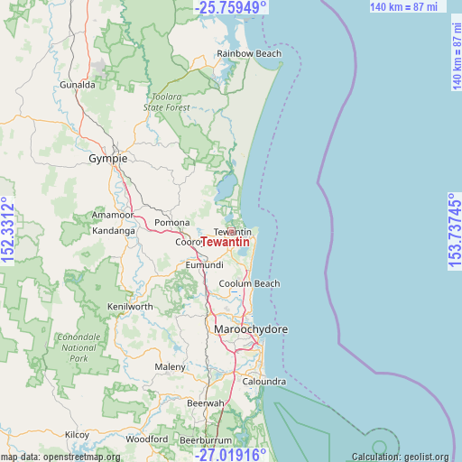
Tewantin GPS coordinates[2]
26° 23' 27.744" South, 153° 2' 3.552" East
| Map corner | latitude | longitude |
|---|---|---|
| Upper-left | -25.75949°, | 152.3312° |
| Center: | -26.39104°, | 153.03432° |
| Lower-right: | -27.01916°, | 153.73745° |
| Map W x H: | 140.1×140.1 km | = 87.1×87.1mi |
| max Lat: | -10.58257° ⇑12% North |
| Tewantin: | -26.39104° |
| min Lat: | ⇓88% South -43.31423° |
| min Long | Tewantin | max Long |
| 113.53327° | 153.03432° | 153.61246° |
| W 92.6%⇐ | ⇒7.4% E |
Elevation
Elevation of Tewantin is 15 m = 49 ft, and this is 107 m = 351 ft below average elevation for this country.
| Max E: |
1715 m = 5627 ft | 80.4% |
| Avg. | 122 m = 400 ft | |
| Tewantin | 15 m = 49 ft | |
Min E: |
-2 m = -7 ft | 19.6% |
See also: Australia elevation on elevation.city.
Geographical zone
Tewantin is located in South temperate zone (between Tropic of Capricorn and the Antarctic Circle). Distance of this Southern Tropic circle is 328.5 km =204.1 mi to North.| Distance of | km | miles | from Tewantin |
|---|---|---|---|
| Equator | 2934.4 | 1823.4 | to North |
| Tropic Capricorn | 328.5 | 204.1 | to North |
| Antarctic Circle | 4466.8 | 2775.5 | to South |
| South Pole | 7072.7 | 4394.8 | to South |


Nearby cities:
15 places around Tewantin: (largest is in red/bold)
• Castaways Beach
7.7 km =4.8 mi,  124°
124°
• Cooroibah
5.7 km =3.5 mi,  302°
302°
• Cooroy
12.6 km =7.8 mi,  256°
256°
• Doonan
6.9 km =4.3 mi,  217°
217°
• Eumundi
12.7 km =7.9 mi, 220°
• Lake Macdonald
10.2 km =6.3 mi,  273°
273°
• Marcus Beach
9.5 km =5.9 mi,  136°
136°
• Noosa Heads
5.6 km =3.5 mi,  93°
93°
• Noosaville
3.4 km =2.1 mi,  107°
107°
• Peregian Beach
11.7 km =7.3 mi,  148°
148°
• Peregian Springs
11.5 km =7.1 mi,  159°
159°
• Sunrise Beach
7.4 km =4.6 mi, 112°
• Sunshine Beach
7.5 km =4.7 mi,  102°
102°
• Tinbeerwah
5.4 km =3.4 mi,  253°
253°
• Verrierdale
10.7 km =6.6 mi,  199°
199°
Sources, notices
• [Note1] Compared only with cities in Australia existing in our database
• [Src1] Map data: © OpenStreetMap contributors (CC-BY-SA)
• [Src2] Other city data from geonames.org with taken over terms of usage.
• [Src3] Geographical zone / Annual Mean Temperature by Robert A. Rohde @ Wikipedia
