Verrierdale geodata
Verrierdale (Queensland) is a section of populated place; located in Australia in Australia/Brisbane (GMT+10) time zone. With population of 764 people, there are 4216 cities with bigger population in this country. Compared to other cities in Australia, 87.6% of cities are located further ↓South; 91.1% of cities are located further ←West and 56.9% of cities have lower elevation than Verrierdale. Note1


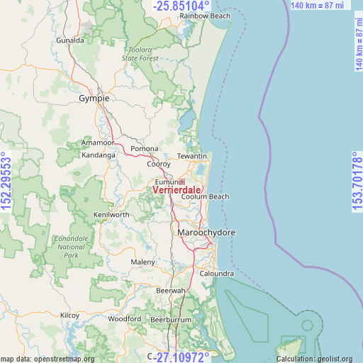
Verrierdale GPS coordinates[2]
26° 28' 55.56" South, 152° 59' 55.14" East
| Map corner | latitude | longitude |
|---|---|---|
| Upper-left | -25.85104°, | 152.29553° |
| Center: | -26.4821°, | 152.99865° |
| Lower-right: | -27.10972°, | 153.70178° |
| Map W x H: | 140×140 km | = 87×87mi |
| max Lat: | -10.58257° ⇑12.4% North |
| Verrierdale: | -26.4821° |
| min Lat: | ⇓87.6% South -43.31423° |
| min Long | Verrierdale | max Long |
| 113.53327° | 152.99865° | 153.61246° |
| W 91.1%⇐ | ⇒8.9% E |
Elevation
Elevation of Verrierdale is 57 m = 187 ft, and this is 65 m = 213 ft below average elevation for this country.
| Max E: |
1715 m = 5627 ft | 43.1% |
| Avg. | 122 m = 400 ft | |
| Verrierdale | 57 m = 187 ft | |
Min E: |
-2 m = -7 ft | 56.9% |
See also: Australia elevation on elevation.city.
Geographical zone
Verrierdale is located in South temperate zone (between Tropic of Capricorn and the Antarctic Circle). Distance of this Southern Tropic circle is 338.6 km =210.4 mi to North.| Distance of | km | miles | from Verrierdale |
|---|---|---|---|
| Equator | 2944.5 | 1829.6 | to North |
| Tropic Capricorn | 338.6 | 210.4 | to North |
| Antarctic Circle | 4456.6 | 2769.2 | to South |
| South Pole | 7062.5 | 4388.4 | to South |


Nearby cities:
15 places around Verrierdale: (largest is in red/bold)
• Coolum Beach
10.3 km =6.4 mi,  119°
119°
• Cooroy
11.2 km =7 mi,  309°
309°
• Doonan
4.8 km =3 mi,  352°
352°
• Eerwah Vale
8.7 km =5.4 mi,  272°
272°
• Eumundi
4.8 km =3 mi,  276°
276°
• Marcus Beach
10.6 km =6.6 mi,  72°
72°
• Maroochy River
10.8 km =6.7 mi,  169°
169°
• Ninderry
6.9 km =4.3 mi,  199°
199°
• North Arm
6.4 km =4 mi,  222°
222°
• Peregian Beach
9.7 km =6 mi,  89°
89°
• Peregian Springs
7.7 km =4.8 mi, 94°
• Tewantin
10.7 km =6.6 mi,  19°
19°
• Tinbeerwah
8.8 km =5.5 mi, 349°
• Yandina
9.8 km =6.1 mi,  205°
205°
• Yandina Creek
7.5 km =4.7 mi,  147°
147°
Sources, notices
• [Note1] Compared only with cities in Australia existing in our database
• [Src1] Map data: © OpenStreetMap contributors (CC-BY-SA)
• [Src2] Other city data from geonames.org with taken over terms of usage.
• [Src3] Geographical zone / Annual Mean Temperature by Robert A. Rohde @ Wikipedia
