Doonan geodata
Doonan (Queensland) is a section of populated place; located in Australia in Australia/Brisbane (GMT+10) time zone. With population of 3,411 people, there are 2022 cities with bigger population in this country. Compared to other cities in Australia, 87.8% of cities are located further ↓South; 90.9% of cities are located further ←West and 63% of cities have lower elevation than Doonan. Note1


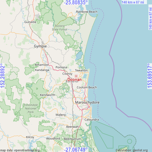
Doonan GPS coordinates[2]
26° 26' 22.704" South, 152° 59' 31.344" East
| Map corner | latitude | longitude |
|---|---|---|
| Upper-left | -25.80835°, | 152.28892° |
| Center: | -26.43964°, | 152.99204° |
| Lower-right: | -27.06749°, | 153.69517° |
| Map W x H: | 140×140 km | = 87×87mi |
| max Lat: | -10.58257° ⇑12.2% North |
| Doonan: | -26.43964° |
| min Lat: | ⇓87.8% South -43.31423° |
| min Long | Doonan | max Long |
| 113.53327° | 152.99204° | 153.61246° |
| W 90.9%⇐ | ⇒9.1% E |
Elevation
Elevation of Doonan is 73 m = 240 ft, and this is 49 m = 161 ft below average elevation for this country.
| Max E: |
1715 m = 5627 ft | 37% |
| Avg. | 122 m = 400 ft | |
| Doonan | 73 m = 240 ft | |
Min E: |
-2 m = -7 ft | 63% |
See also: Australia elevation on elevation.city.
Geographical zone
Doonan is located in South temperate zone (between Tropic of Capricorn and the Antarctic Circle). Distance of this Southern Tropic circle is 333.9 km =207.5 mi to North.| Distance of | km | miles | from Doonan |
|---|---|---|---|
| Equator | 2939.8 | 1826.7 | to North |
| Tropic Capricorn | 333.9 | 207.5 | to North |
| Antarctic Circle | 4461.4 | 2772.2 | to South |
| South Pole | 7067.2 | 4391.4 | to South |


Nearby cities:
15 places around Doonan: (largest is in red/bold)
• Castaways Beach
10.6 km =6.6 mi,  84°
84°
• Cooroibah
8.5 km =5.3 mi,  355°
355°
• Cooroy
8.4 km =5.2 mi,  286°
286°
• Eerwah Vale
9.2 km =5.7 mi,  241°
241°
• Eumundi
5.8 km =3.6 mi,  224°
224°
• Lake Macdonald
8.5 km =5.3 mi,  315°
315°
• Marcus Beach
10.9 km =6.8 mi,  97°
97°
• Noosa Heads
11 km =6.8 mi,  62°
62°
• Noosaville
8.6 km =5.3 mi, 59°
• North Arm
10.2 km =6.3 mi,  201°
201°
• Peregian Springs
9.9 km =6.2 mi,  122°
122°
• Sunrise Beach
11.3 km =7 mi, 76°
• Tewantin
6.9 km =4.3 mi,  37°
37°
• Tinbeerwah
4 km =2.5 mi,  346°
346°
• Verrierdale
4.8 km =3 mi,  172°
172°
Sources, notices
• [Note1] Compared only with cities in Australia existing in our database
• [Src1] Map data: © OpenStreetMap contributors (CC-BY-SA)
• [Src2] Other city data from geonames.org with taken over terms of usage.
• [Src3] Geographical zone / Annual Mean Temperature by Robert A. Rohde @ Wikipedia
