Noosaville geodata
Noosaville (Queensland) is a section of populated place; located in Australia in Australia/Brisbane (GMT+10) time zone. With population of 9,811 people, there are 618 cities with bigger population in this country. Compared to other cities in Australia, 87.9% of cities are located further ↓South; 93.7% of cities are located further ←West and 95.5% of cities have higher elevation than Noosaville. Note1


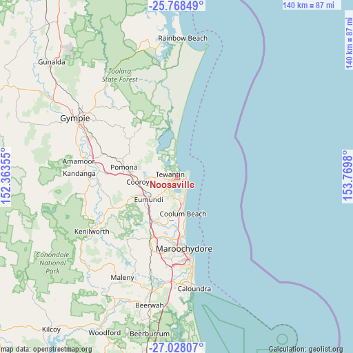
Noosaville GPS coordinates[2]
26° 24' 0" South, 153° 4' 0.012" East
| Map corner | latitude | longitude |
|---|---|---|
| Upper-left | -25.76849°, | 152.36355° |
| Center: | -26.4°, | 153.06667° |
| Lower-right: | -27.02807°, | 153.7698° |
| Map W x H: | 140.1×140.1 km | = 87.1×87.1mi |
| max Lat: | -10.58257° ⇑12.1% North |
| Noosaville: | -26.4° |
| min Lat: | ⇓87.9% South -43.31423° |
| min Long | Noosaville | max Long |
| 113.53327° | 153.06667° | 153.61246° |
| W 93.7%⇐ | ⇒6.3% E |
Elevation
Elevation of Noosaville is 6 m = 20 ft, and this is 116 m = 381 ft below average elevation for this country.
| Max E: |
1715 m = 5627 ft | 95.5% |
| Avg. | 122 m = 400 ft | |
| Noosaville | 6 m = 20 ft | |
Min E: |
-2 m = -7 ft | 4.5% |
See also: Australia elevation on elevation.city.
Geographical zone
Noosaville is located in South temperate zone (between Tropic of Capricorn and the Antarctic Circle). Distance of this Southern Tropic circle is 329.5 km =204.7 mi to North.| Distance of | km | miles | from Noosaville |
|---|---|---|---|
| Equator | 2935.4 | 1824 | to North |
| Tropic Capricorn | 329.5 | 204.7 | to North |
| Antarctic Circle | 4465.8 | 2774.9 | to South |
| South Pole | 7071.7 | 4394.1 | to South |


Nearby cities:
15 places around Noosaville: (largest is in red/bold)
• Castaways Beach
4.5 km =2.8 mi,  136°
136°
• Coolum Beach
14.4 km =8.9 mi,  171°
171°
• Cooroibah
9 km =5.6 mi,  297°
297°
• Doonan
8.6 km =5.3 mi,  239°
239°
• Eumundi
14.4 km =8.9 mi,  233°
233°
• Lake Macdonald
13.5 km =8.4 mi,  277°
277°
• Marcus Beach
6.8 km =4.2 mi,  150°
150°
• Noosa Heads
2.4 km =1.5 mi,  74°
74°
• Peregian Beach
9.5 km =5.9 mi,  162°
162°
• Peregian Springs
9.8 km =6.1 mi, 174°
• Sunrise Beach
4.1 km =2.5 mi,  116°
116°
• Sunshine Beach
4.1 km =2.5 mi,  98°
98°
• Tewantin
3.4 km =2.1 mi,  287°
287°
• Tinbeerwah
8.4 km =5.2 mi,  266°
266°
• Verrierdale
11.4 km =7.1 mi,  216°
216°
Sources, notices
• [Note1] Compared only with cities in Australia existing in our database
• [Src1] Map data: © OpenStreetMap contributors (CC-BY-SA)
• [Src2] Other city data from geonames.org with taken over terms of usage.
• [Src3] Geographical zone / Annual Mean Temperature by Robert A. Rohde @ Wikipedia
