Eumundi geodata
Eumundi (Queensland) is a section of populated place; located in Australia in Australia/Brisbane (GMT+10) time zone. With population of 2,194 people, there are 2761 cities with bigger population in this country. Compared to other cities in Australia, 87.7% of cities are located further ↓South; 89.6% of cities are located further ←West and 58.5% of cities have lower elevation than Eumundi. Note1


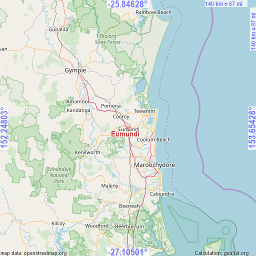
Eumundi GPS coordinates[2]
26° 28' 38.532" South, 152° 57' 4.14" East
| Map corner | latitude | longitude |
|---|---|---|
| Upper-left | -25.84628°, | 152.24803° |
| Center: | -26.47737°, | 152.95115° |
| Lower-right: | -27.10501°, | 153.65428° |
| Map W x H: | 140×140 km | = 87×87mi |
| max Lat: | -10.58257° ⇑12.3% North |
| Eumundi: | -26.47737° |
| min Lat: | ⇓87.7% South -43.31423° |
| min Long | Eumundi | max Long |
| 113.53327° | 152.95115° | 153.61246° |
| W 89.6%⇐ | ⇒10.4% E |
Elevation
Elevation of Eumundi is 60 m = 197 ft, and this is 62 m = 203 ft below average elevation for this country.
| Max E: |
1715 m = 5627 ft | 41.5% |
| Avg. | 122 m = 400 ft | |
| Eumundi | 60 m = 197 ft | |
Min E: |
-2 m = -7 ft | 58.5% |
See also: Australia elevation on elevation.city.
Geographical zone
Eumundi is located in South temperate zone (between Tropic of Capricorn and the Antarctic Circle). Distance of this Southern Tropic circle is 338.1 km =210.1 mi to North.| Distance of | km | miles | from Eumundi |
|---|---|---|---|
| Equator | 2944 | 1829.3 | to North |
| Tropic Capricorn | 338.1 | 210.1 | to North |
| Antarctic Circle | 4457.2 | 2769.6 | to South |
| South Pole | 7063.1 | 4388.8 | to South |


Nearby cities:
15 places around Eumundi: (largest is in red/bold)
• Black Mountain
11.5 km =7.1 mi,  319°
319°
• Cooroibah
13.2 km =8.2 mi,  15°
15°
• Cooroy
7.7 km =4.8 mi,  329°
329°
• Doonan
5.8 km =3.6 mi,  44°
44°
• Eerwah Vale
4 km =2.5 mi,  266°
266°
• Lake Macdonald
10.5 km =6.5 mi,  349°
349°
• Maroochy River
13 km =8.1 mi,  148°
148°
• Ninderry
7.5 km =4.7 mi,  161°
161°
• North Arm
5.3 km =3.3 mi,  175°
175°
• Peregian Springs
12.5 km =7.8 mi,  95°
95°
• Tewantin
12.7 km =7.9 mi, 40°
• Tinbeerwah
8.7 km =5.4 mi, 21°
• Verrierdale
4.8 km =3 mi, 96°
• Yandina
9.4 km =5.8 mi, 177°
• Yandina Creek
11.1 km =6.9 mi,  127°
127°
Sources, notices
• [Note1] Compared only with cities in Australia existing in our database
• [Src1] Map data: © OpenStreetMap contributors (CC-BY-SA)
• [Src2] Other city data from geonames.org with taken over terms of usage.
• [Src3] Geographical zone / Annual Mean Temperature by Robert A. Rohde @ Wikipedia
