Frederickton geodata
Frederickton (New South Wales) is a populated place; located in Australia in Australia/Sydney (GMT+11) time zone. With population of 1,395 people, there are 3378 cities with bigger population in this country. Compared to other cities in Australia, 70.7% of cities are located further ↓South; 88.1% of cities are located further ←West and 95.5% of cities have higher elevation than Frederickton. Note1


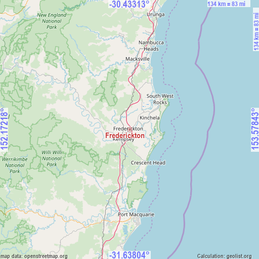
Frederickton GPS coordinates[2]
31° 2' 14.964" South, 152° 52' 31.08" East
| Map corner | latitude | longitude |
|---|---|---|
| Upper-left | -30.43313°, | 152.17218° |
| Center: | -31.03749°, | 152.8753° |
| Lower-right: | -31.63804°, | 153.57843° |
| Map W x H: | 134×134 km | = 83.3×83.3mi |
| max Lat: | -10.58257° ⇑29.3% North |
| Frederickton: | -31.03749° |
| min Lat: | ⇓70.7% South -43.31423° |
| min Long | Frederickton | max Long |
| 113.53327° | 152.8753° | 153.61246° |
| W 88.1%⇐ | ⇒11.9% E |
Elevation
Elevation of Frederickton is 6 m = 20 ft, and this is 116 m = 381 ft below average elevation for this country.
| Max E: |
1715 m = 5627 ft | 95.5% |
| Avg. | 122 m = 400 ft | |
| Frederickton | 6 m = 20 ft | |
Min E: |
-2 m = -7 ft | 4.5% |
See also: Australia elevation on elevation.city.
Geographical zone
Frederickton is located in South temperate zone (between Tropic of Capricorn and the Antarctic Circle). Distance of this Southern Tropic circle is 845.1 km =525.1 mi to North.| Distance of | km | miles | from Frederickton |
|---|---|---|---|
| Equator | 3451 | 2144.4 | to North |
| Tropic Capricorn | 845.1 | 525.1 | to North |
| Antarctic Circle | 3950.1 | 2454.5 | to South |
| South Pole | 6556 | 4073.7 | to South |


Nearby cities:
15 places around Frederickton: (largest is in red/bold)
• Aldavilla
11.4 km =7.1 mi,  244°
244°
• Collombatti
7.9 km =4.9 mi,  322°
322°
• Crescent Head
19.2 km =11.9 mi,  151°
151°
• Dondingalong
15.9 km =9.9 mi,  227°
227°
• East Kempsey
5.4 km =3.4 mi,  203°
203°
• Green Hill
7.4 km =4.6 mi,  251°
251°
• Kempsey
6.3 km =3.9 mi,  222°
222°
• Kempsey city centre
5.8 km =3.6 mi, 220°
• Kundabung
19.6 km =12.2 mi,  192°
192°
• Smithtown
7.1 km =4.4 mi,  68°
68°
• South Kempsey
10.3 km =6.4 mi, 203°
• South West Rocks
23.1 km =14.4 mi,  43°
43°
• Stuarts Point
26.6 km =16.5 mi,  25°
25°
• West Kempsey
5 km =3.1 mi, 243°
• Yarravel
10.8 km =6.7 mi,  266°
266°
Sources, notices
• [Note1] Compared only with cities in Australia existing in our database
• [Src1] Map data: © OpenStreetMap contributors (CC-BY-SA)
• [Src2] Other city data from geonames.org with taken over terms of usage.
• [Src3] Geographical zone / Annual Mean Temperature by Robert A. Rohde @ Wikipedia
