Springwood geodata
Springwood (New South Wales) is a section of populated place; located in Australia in Australia/Sydney (GMT+11) time zone. With population of 8,358 people, there are 778 cities with bigger population in this country. Compared to other cities in Australia, 51.3% of cities are located further ↓South; 59.1% of cities are located further ←West and 89.4% of cities have lower elevation than Springwood. Note1


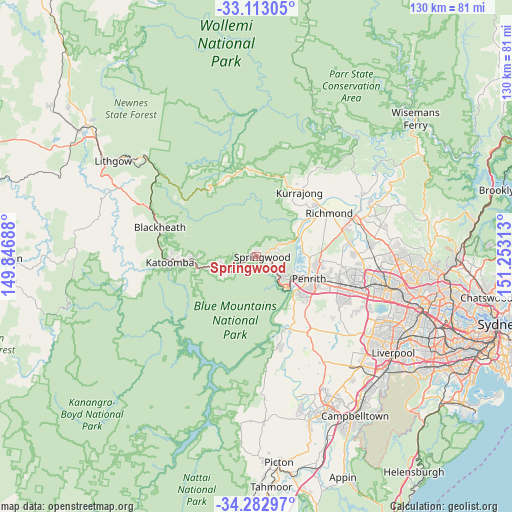
Springwood GPS coordinates[2]
33° 42' 0" South, 150° 33' 0" East
| Map corner | latitude | longitude |
|---|---|---|
| Upper-left | -33.11305°, | 149.84688° |
| Center: | -33.7°, | 150.55° |
| Lower-right: | -34.28297°, | 151.25313° |
| Map W x H: | 130.1×130.1 km | = 80.8×80.8mi |
| max Lat: | -10.58257° ⇑48.7% North |
| Springwood: | -33.7° |
| min Lat: | ⇓51.3% South -43.31423° |
| min Long | Springwood | max Long |
| 113.53327° | 150.55° | 153.61246° |
| W 59.1%⇐ | ⇒40.9% E |
Elevation
Elevation of Springwood is 357 m = 1171 ft, and this is 235 m = 771 ft above average elevation for this country.
| Max E: |
1715 m = 5627 ft | 10.6% |
| Springwood | 357 m 1171 ft | |
| Avg. | 122 m = 400 ft | |
Min E: |
-2 m = -7 ft | 89.4% |
See also: Australia elevation on elevation.city.
Geographical zone
Springwood is located in South temperate zone (between Tropic of Capricorn and the Antarctic Circle). Distance of this Southern Tropic circle is 1141.2 km =709.1 mi to North.| Distance of | km | miles | from Springwood |
|---|---|---|---|
| Equator | 3747.1 | 2328.3 | to North |
| Tropic Capricorn | 1141.2 | 709.1 | to North |
| Antarctic Circle | 3654.1 | 2270.6 | to South |
| South Pole | 6260 | 3889.8 | to South |


Nearby cities:
15 places around Springwood: (largest is in red/bold)
• Blaxland
7.2 km =4.5 mi,  140°
140°
• Castlereagh
12 km =7.5 mi,  84°
84°
• Emu Heights
9.9 km =6.2 mi,  112°
112°
• Faulconbridge
1.5 km =0.9 mi,  270°
270°
• Glenbrook
9.6 km =6 mi, 140°
• Hazelbrook
8.9 km =5.5 mi,  252°
252°
• Lapstone
11.4 km =7.1 mi, 136°
• Lawson
11.4 km =7.1 mi,  258°
258°
• Leonay
11.6 km =7.2 mi,  128°
128°
• Mount Riverview
8.6 km =5.3 mi, 113°
• Valley Heights
3.1 km =1.9 mi,  90°
90°
• Warrimoo
5 km =3.1 mi, 111°
• Winmalee
6.2 km =3.9 mi,  67°
67°
• Woodford
7.2 km =4.5 mi,  238°
238°
• Yellow Rock
7.8 km =4.8 mi, 88°
Sources, notices
• [Note1] Compared only with cities in Australia existing in our database
• [Src1] Map data: © OpenStreetMap contributors (CC-BY-SA)
• [Src2] Other city data from geonames.org with taken over terms of usage.
• [Src3] Geographical zone / Annual Mean Temperature by Robert A. Rohde @ Wikipedia
