Snake Valley geodata
Snake Valley (Victoria) is a populated place; located in Australia in Australia/Melbourne (GMT+11) time zone. With population of 717 people, there are 4299 cities with bigger population in this country. Compared to other cities in Australia, 83.7% of cities are located further ↑North; 73.6% of cities are located further →East and 90.7% of cities have lower elevation than Snake Valley. Note1


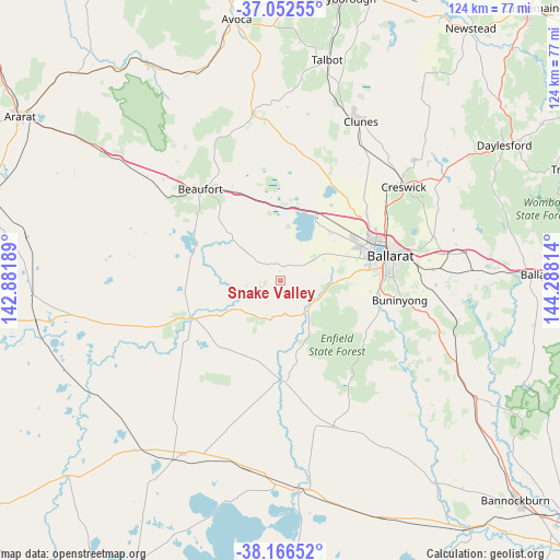
Snake Valley GPS coordinates[2]
37° 36' 41.832" South, 143° 35' 6.036" East
| Map corner | latitude | longitude |
|---|---|---|
| Upper-left | -37.05255°, | 142.88189° |
| Center: | -37.61162°, | 143.58501° |
| Lower-right: | -38.16652°, | 144.28814° |
| Map W x H: | 123.9×123.9 km | = 77×77mi |
| max Lat: | -10.58257° ⇑83.7% North |
| Snake Valley: | -37.61162° |
| min Lat: | ⇓16.3% South -43.31423° |
| min Long | Snake Valley | max Long |
| 113.53327° | 143.58501° | 153.61246° |
| W 26.4%⇐ | ⇒73.6% E |
Elevation
Elevation of Snake Valley is 402 m = 1319 ft, and this is 280 m = 919 ft above average elevation for this country.
| Max E: |
1715 m = 5627 ft | 9.3% |
| Snake Valley | 402 m 1319 ft | |
| Avg. | 122 m = 400 ft | |
Min E: |
-2 m = -7 ft | 90.7% |
See also: Australia elevation on elevation.city.
Geographical zone
Snake Valley is located in South temperate zone (between Tropic of Capricorn and the Antarctic Circle). Distance of this Southern Tropic circle is 1576.1 km =979.3 mi to North.| Distance of | km | miles | from Snake Valley |
|---|---|---|---|
| Equator | 4182 | 2598.6 | to North |
| Tropic Capricorn | 1576.1 | 979.3 | to North |
| Antarctic Circle | 3219.2 | 2000.3 | to South |
| South Pole | 5825 | 3619.5 | to South |


Nearby cities:
15 places around Snake Valley: (largest is in red/bold)
• Alfredton
21 km =13 mi,  76°
76°
• Cardigan
16.9 km =10.5 mi,  59°
59°
• Cardigan Village
15.5 km =9.6 mi,  47°
47°
• Delacombe
20.4 km =12.7 mi, 82°
• Haddon
11.7 km =7.3 mi, 83°
• Lake Gardens
21.7 km =13.5 mi,  70°
70°
• Linton
8.5 km =5.3 mi,  193°
193°
• Lucas
18.3 km =11.4 mi, 66°
• Mitchell Park
20.7 km =12.9 mi, 55°
• Newington
21.9 km =13.6 mi, 74°
• Ross Creek
15.1 km =9.4 mi,  106°
106°
• Scarsdale
10.4 km =6.5 mi,  136°
136°
• Skipton
21.1 km =13.1 mi,  246°
246°
• Smythes Creek
17.5 km =10.9 mi,  85°
85°
• Smythesdale
9.6 km =6 mi, 111°
Sources, notices
• [Note1] Compared only with cities in Australia existing in our database
• [Src1] Map data: © OpenStreetMap contributors (CC-BY-SA)
• [Src2] Other city data from geonames.org with taken over terms of usage.
• [Src3] Geographical zone / Annual Mean Temperature by Robert A. Rohde @ Wikipedia
