Linton geodata
Linton (Victoria) is a populated place; located in Australia in Australia/Melbourne (GMT+11) time zone. With population of 574 people, there are 4635 cities with bigger population in this country. Compared to other cities in Australia, 84.5% of cities are located further ↑North; 73.6% of cities are located further →East and 89.1% of cities have lower elevation than Linton. Note1


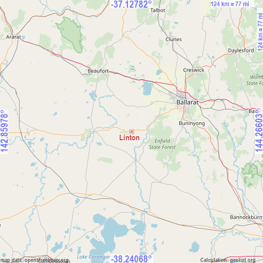
Linton GPS coordinates[2]
37° 41' 10.824" South, 143° 33' 46.44" East
| Map corner | latitude | longitude |
|---|---|---|
| Upper-left | -37.12782°, | 142.85978° |
| Center: | -37.68634°, | 143.5629° |
| Lower-right: | -38.24068°, | 144.26603° |
| Map W x H: | 123.7×123.7 km | = 76.9×76.9mi |
| max Lat: | -10.58257° ⇑84.5% North |
| Linton: | -37.68634° |
| min Lat: | ⇓15.5% South -43.31423° |
| min Long | Linton | max Long |
| 113.53327° | 143.5629° | 153.61246° |
| W 26.4%⇐ | ⇒73.6% E |
Elevation
Elevation of Linton is 349 m = 1145 ft, and this is 227 m = 745 ft above average elevation for this country.
| Max E: |
1715 m = 5627 ft | 10.9% |
| Linton | 349 m 1145 ft | |
| Avg. | 122 m = 400 ft | |
Min E: |
-2 m = -7 ft | 89.1% |
See also: Australia elevation on elevation.city.
Geographical zone
Linton is located in South temperate zone (between Tropic of Capricorn and the Antarctic Circle). Distance of this Southern Tropic circle is 1584.4 km =984.5 mi to North.| Distance of | km | miles | from Linton |
|---|---|---|---|
| Equator | 4190.3 | 2603.7 | to North |
| Tropic Capricorn | 1584.4 | 984.5 | to North |
| Antarctic Circle | 3210.8 | 1995.1 | to South |
| South Pole | 5816.7 | 3614.3 | to South |


Nearby cities:
15 places around Linton: (largest is in red/bold)
• Alfredton
26 km =16.2 mi,  59°
59°
• Cardigan
23.7 km =14.7 mi,  44°
44°
• Cardigan Village
23.1 km =14.4 mi, 35°
• Delacombe
24.7 km =15.3 mi, 64°
• Dereel
23 km =14.3 mi,  128°
128°
• Enfield
20.9 km =13 mi,  102°
102°
• Haddon
16.6 km =10.3 mi,  54°
54°
• Lucas
24.4 km =15.2 mi, 50°
• Napoleons
23.9 km =14.9 mi,  84°
84°
• Ross Creek
17 km =10.6 mi, 76°
• Scarsdale
9.2 km =5.7 mi,  85°
85°
• Skipton
17.4 km =10.8 mi,  270°
270°
• Smythes Creek
21.7 km =13.5 mi, 63°
• Smythesdale
11.9 km =7.4 mi,  66°
66°
• Snake Valley
8.5 km =5.3 mi,  13°
13°
Sources, notices
• [Note1] Compared only with cities in Australia existing in our database
• [Src1] Map data: © OpenStreetMap contributors (CC-BY-SA)
• [Src2] Other city data from geonames.org with taken over terms of usage.
• [Src3] Geographical zone / Annual Mean Temperature by Robert A. Rohde @ Wikipedia
