Seville geodata
Seville (Victoria) is a section of populated place; located in Australia in Australia/Melbourne (GMT+11) time zone. With population of 2,315 people, there are 2684 cities with bigger population in this country. Compared to other cities in Australia, 87.4% of cities are located further ↑North; 59.7% of cities are located further →East and 77.4% of cities have lower elevation than Seville. Note1


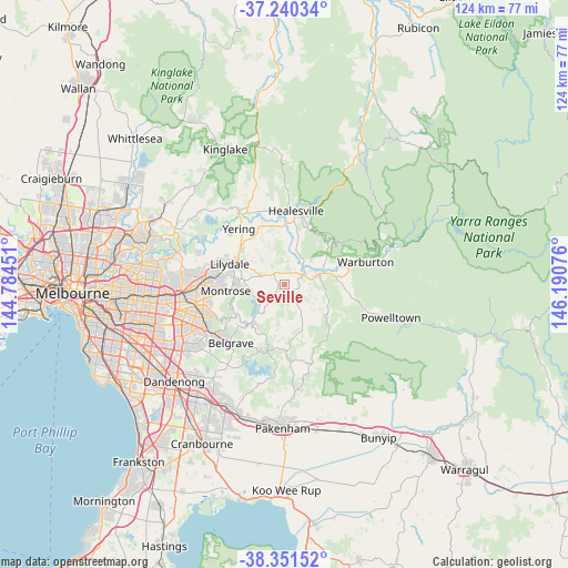
Seville GPS coordinates[2]
37° 47' 52.872" South, 145° 29' 15.468" East
| Map corner | latitude | longitude |
|---|---|---|
| Upper-left | -37.24034°, | 144.78451° |
| Center: | -37.79802°, | 145.48763° |
| Lower-right: | -38.35152°, | 146.19076° |
| Map W x H: | 123.6×123.6 km | = 76.8×76.8mi |
| max Lat: | -10.58257° ⇑87.4% North |
| Seville: | -37.79802° |
| min Lat: | ⇓12.6% South -43.31423° |
| min Long | Seville | max Long |
| 113.53327° | 145.48763° | 153.61246° |
| W 40.3%⇐ | ⇒59.7% E |
Elevation
Elevation of Seville is 151 m = 495 ft, and this is 29 m = 95 ft above average elevation for this country.
| Max E: |
1715 m = 5627 ft | 22.6% |
| Seville | 151 m 495 ft | |
| Avg. | 122 m = 400 ft | |
Min E: |
-2 m = -7 ft | 77.4% |
See also: Australia elevation on elevation.city.
Geographical zone
Seville is located in South temperate zone (between Tropic of Capricorn and the Antarctic Circle). Distance of this Southern Tropic circle is 1596.8 km =992.2 mi to North.| Distance of | km | miles | from Seville |
|---|---|---|---|
| Equator | 4202.7 | 2611.4 | to North |
| Tropic Capricorn | 1596.8 | 992.2 | to North |
| Antarctic Circle | 3198.4 | 1987.4 | to South |
| South Pole | 5804.3 | 3606.6 | to South |


Nearby cities:
15 places around Seville: (largest is in red/bold)
• Badger Creek
11.2 km =7 mi,  13°
13°
• Gruyere
7.9 km =4.9 mi,  335°
335°
• Hoddles Creek
9.3 km =5.8 mi,  115°
115°
• Kalorama
10.8 km =6.7 mi,  258°
258°
• Launching Place
7.4 km =4.6 mi,  74°
74°
• Macclesfield
9.5 km =5.9 mi,  182°
182°
• Monbulk
10.1 km =6.3 mi,  212°
212°
• Mount Dandenong
11.3 km =7 mi,  249°
249°
• Mount Evelyn
9.3 km =5.8 mi,  280°
280°
• Seville East
2.7 km =1.7 mi,  18°
18°
• Silvan
6.6 km =4.1 mi, 251°
• Wandin North
5 km =3.1 mi,  288°
288°
• Woori Yallock
4.8 km =3 mi, 66°
• Yarra Junction
11.3 km =7 mi,  80°
80°
• Yellingbo
6.5 km =4 mi,  145°
145°
Sources, notices
• [Note1] Compared only with cities in Australia existing in our database
• [Src1] Map data: © OpenStreetMap contributors (CC-BY-SA)
• [Src2] Other city data from geonames.org with taken over terms of usage.
• [Src3] Geographical zone / Annual Mean Temperature by Robert A. Rohde @ Wikipedia
