Launching Place geodata
Launching Place (Victoria) is a section of populated place; located in Australia in Australia/Melbourne (GMT+11) time zone. With population of 2,319 people, there are 2682 cities with bigger population in this country. Compared to other cities in Australia, 86.9% of cities are located further ↑North; 59.3% of cities are located further →East and 77.1% of cities have lower elevation than Launching Place. Note1


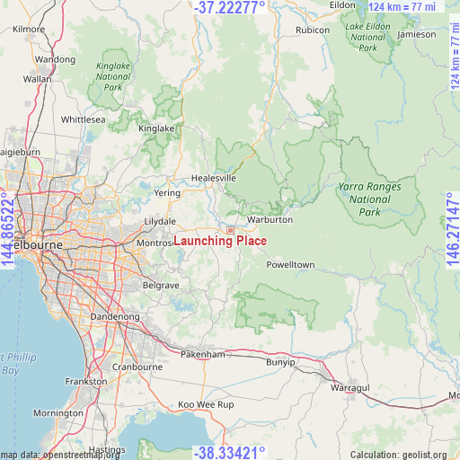
Launching Place GPS coordinates[2]
37° 46' 50.088" South, 145° 34' 6.024" East
| Map corner | latitude | longitude |
|---|---|---|
| Upper-left | -37.22277°, | 144.86522° |
| Center: | -37.78058°, | 145.56834° |
| Lower-right: | -38.33421°, | 146.27147° |
| Map W x H: | 123.6×123.6 km | = 76.8×76.8mi |
| max Lat: | -10.58257° ⇑86.9% North |
| Launching Place: | -37.78058° |
| min Lat: | ⇓13.1% South -43.31423° |
| min Long | Launching Place | max Long |
| 113.53327° | 145.56834° | 153.61246° |
| W 40.7%⇐ | ⇒59.3% E |
Elevation
Elevation of Launching Place is 149 m = 489 ft, and this is 27 m = 89 ft above average elevation for this country.
| Max E: |
1715 m = 5627 ft | 22.9% |
| Launching Place | 149 m 489 ft | |
| Avg. | 122 m = 400 ft | |
Min E: |
-2 m = -7 ft | 77.1% |
See also: Australia elevation on elevation.city.
Geographical zone
Launching Place is located in South temperate zone (between Tropic of Capricorn and the Antarctic Circle). Distance of this Southern Tropic circle is 1594.9 km =991 mi to North.| Distance of | km | miles | from Launching Place |
|---|---|---|---|
| Equator | 4200.8 | 2610.3 | to North |
| Tropic Capricorn | 1594.9 | 991 | to North |
| Antarctic Circle | 3200.4 | 1988.6 | to South |
| South Pole | 5806.3 | 3607.9 | to South |


Nearby cities:
15 places around Launching Place: (largest is in red/bold)
• Badger Creek
10 km =6.2 mi,  333°
333°
• Don Valley
5.3 km =3.3 mi,  23°
23°
• Gruyere
11.7 km =7.3 mi,  296°
296°
• Hoddles Creek
6 km =3.7 mi,  167°
167°
• Macclesfield
13.6 km =8.5 mi,  213°
213°
• Millgrove
8 km =5 mi,  69°
69°
• Seville
7.4 km =4.6 mi,  254°
254°
• Seville East
6.3 km =3.9 mi,  275°
275°
• Silvan
13.9 km =8.6 mi, 253°
• Wandin North
11.9 km =7.4 mi,  268°
268°
• Warburton
11.1 km =6.9 mi, 74°
• Wesburn
5.9 km =3.7 mi, 74°
• Woori Yallock
2.6 km =1.6 mi, 269°
• Yarra Junction
4 km =2.5 mi,  92°
92°
• Yellingbo
8 km =5 mi, 205°
Sources, notices
• [Note1] Compared only with cities in Australia existing in our database
• [Src1] Map data: © OpenStreetMap contributors (CC-BY-SA)
• [Src2] Other city data from geonames.org with taken over terms of usage.
• [Src3] Geographical zone / Annual Mean Temperature by Robert A. Rohde @ Wikipedia
