Macclesfield geodata
Macclesfield (Victoria) is a section of populated place; located in Australia in Australia/Melbourne (GMT+11) time zone. With population of 797 people, there are 4155 cities with bigger population in this country. Compared to other cities in Australia, 90% of cities are located further ↑North; 59.8% of cities are located further →East and 80.2% of cities have lower elevation than Macclesfield. Note1


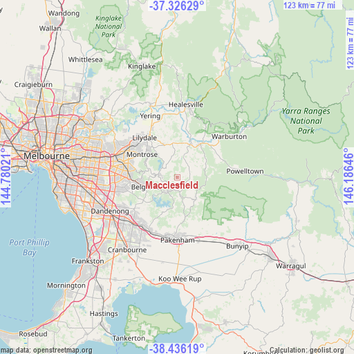
Macclesfield GPS coordinates[2]
37° 52' 59.988" South, 145° 28' 59.988" East
| Map corner | latitude | longitude |
|---|---|---|
| Upper-left | -37.32629°, | 144.78021° |
| Center: | -37.88333°, | 145.48333° |
| Lower-right: | -38.43619°, | 146.18646° |
| Map W x H: | 123.4×123.4 km | = 76.7×76.7mi |
| max Lat: | -10.58257° ⇑90% North |
| Macclesfield: | -37.88333° |
| min Lat: | ⇓10% South -43.31423° |
| min Long | Macclesfield | max Long |
| 113.53327° | 145.48333° | 153.61246° |
| W 40.2%⇐ | ⇒59.8% E |
Elevation
Elevation of Macclesfield is 183 m = 600 ft, and this is 61 m = 200 ft above average elevation for this country.
| Max E: |
1715 m = 5627 ft | 19.8% |
| Macclesfield | 183 m 600 ft | |
| Avg. | 122 m = 400 ft | |
Min E: |
-2 m = -7 ft | 80.2% |
See also: Australia elevation on elevation.city.
Geographical zone
Macclesfield is located in South temperate zone (between Tropic of Capricorn and the Antarctic Circle). Distance of this Southern Tropic circle is 1606.3 km =998.1 mi to North.| Distance of | km | miles | from Macclesfield |
|---|---|---|---|
| Equator | 4212.2 | 2617.3 | to North |
| Tropic Capricorn | 1606.3 | 998.1 | to North |
| Antarctic Circle | 3188.9 | 1981.5 | to South |
| South Pole | 5794.8 | 3600.7 | to South |


Nearby cities:
15 places around Macclesfield: (largest is in red/bold)
• Avonsleigh
3.2 km =2 mi,  178°
178°
• Cockatoo
6 km =3.7 mi,  171°
171°
• Emerald
6.5 km =4 mi,  214°
214°
• Gembrook
10 km =6.2 mi,  140°
140°
• Hoddles Creek
10.4 km =6.5 mi,  57°
57°
• Kallista
9 km =5.6 mi,  259°
259°
• Menzies Creek
8.2 km =5.1 mi,  243°
243°
• Monbulk
5.1 km =3.2 mi,  281°
281°
• Mount Dandenong
11.7 km =7.3 mi,  298°
298°
• Olinda
10.9 km =6.8 mi,  289°
289°
• Selby
9.5 km =5.9 mi,  247°
247°
• Seville
9.5 km =5.9 mi,  2°
2°
• Silvan
9.4 km =5.8 mi,  321°
321°
• The Patch
7.2 km =4.5 mi, 262°
• Yellingbo
5.8 km =3.6 mi,  44°
44°
Sources, notices
• [Note1] Compared only with cities in Australia existing in our database
• [Src1] Map data: © OpenStreetMap contributors (CC-BY-SA)
• [Src2] Other city data from geonames.org with taken over terms of usage.
• [Src3] Geographical zone / Annual Mean Temperature by Robert A. Rohde @ Wikipedia
