Scottsdale geodata
Scottsdale (Tasmania) is a populated place; located in Australia in Australia/Hobart (GMT+11) time zone. With population of 2,302 people, there are 2691 cities with bigger population in this country. Compared to other cities in Australia, 96.8% of cities are located further ↑North; 50.1% of cities are located further ←West and 81.8% of cities have lower elevation than Scottsdale. Note1


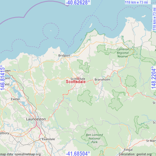
Scottsdale GPS coordinates[2]
41° 9' 28.08" South, 147° 31' 2.172" East
| Map corner | latitude | longitude |
|---|---|---|
| Upper-left | -40.62628°, | 146.81415° |
| Center: | -41.1578°, | 147.51727° |
| Lower-right: | -41.68504°, | 148.2204° |
| Map W x H: | 117.7×117.7 km | = 73.1×73.1mi |
| max Lat: | -10.58257° ⇑96.8% North |
| Scottsdale: | -41.1578° |
| min Lat: | ⇓3.2% South -43.31423° |
| min Long | Scottsdale | max Long |
| 113.53327° | 147.51727° | 153.61246° |
| W 50.1%⇐ | ⇒49.9% E |
Elevation
Elevation of Scottsdale is 202 m = 663 ft, and this is 80 m = 262 ft above average elevation for this country.
| Max E: |
1715 m = 5627 ft | 18.2% |
| Scottsdale | 202 m 663 ft | |
| Avg. | 122 m = 400 ft | |
Min E: |
-2 m = -7 ft | 81.8% |
See also: Australia elevation on elevation.city.
Geographical zone
Scottsdale is located in South temperate zone (between Tropic of Capricorn and the Antarctic Circle). Distance of this Southern Tropic circle is 1970.4 km =1224.3 mi to North.| Distance of | km | miles | from Scottsdale |
|---|---|---|---|
| Equator | 4576.3 | 2843.6 | to North |
| Tropic Capricorn | 1970.4 | 1224.3 | to North |
| Antarctic Circle | 2824.9 | 1755.3 | to South |
| South Pole | 5430.7 | 3374.5 | to South |


Nearby cities:
15 places around Scottsdale: (largest is in red/bold)
• Bridport
20.4 km =12.7 mi,  328°
328°
• Dilston
42.3 km =26.3 mi,  243°
243°
• East Launceston
43.7 km =27.2 mi,  224°
224°
• Invermay
43.4 km =27 mi,  227°
227°
• Launceston city centre
44.1 km =27.4 mi, 225°
• Lilydale
27.1 km =16.8 mi,  247°
247°
• Mayfield
41.2 km =25.6 mi, 231°
• Mowbray
41 km =25.5 mi, 228°
• Newnham
42.4 km =26.3 mi, 232°
• Newstead
43.3 km =26.9 mi, 223°
• Norwood
43.7 km =27.2 mi, 219°
• Ravenswood
40.1 km =24.9 mi, 224°
• Rocherlea
39 km =24.2 mi, 230°
• Saint Leonards
42.5 km =26.4 mi, 218°
• Waverley
41.5 km =25.8 mi, 221°
Sources, notices
• [Note1] Compared only with cities in Australia existing in our database
• [Src1] Map data: © OpenStreetMap contributors (CC-BY-SA)
• [Src2] Other city data from geonames.org with taken over terms of usage.
• [Src3] Geographical zone / Annual Mean Temperature by Robert A. Rohde @ Wikipedia
