Lilydale geodata
Lilydale (Tasmania) is a populated place; located in Australia in Australia/Hobart (GMT+11) time zone. With population of 568 people, there are 4654 cities with bigger population in this country. Compared to other cities in Australia, 97.1% of cities are located further ↑North; 51.9% of cities are located further →East and 78.5% of cities have lower elevation than Lilydale. Note1


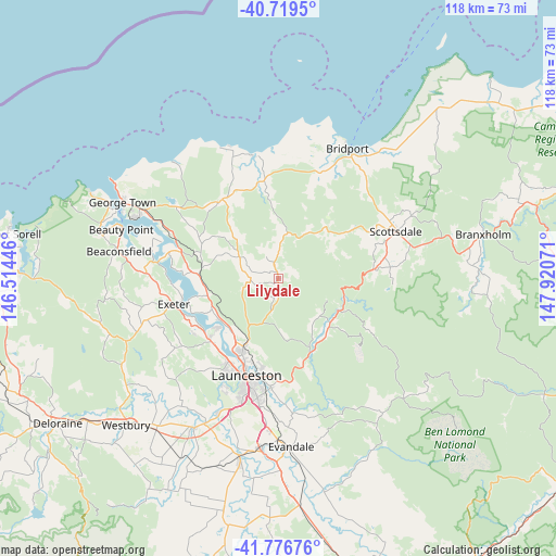
Lilydale GPS coordinates[2]
41° 15' 0.972" South, 147° 13' 3.288" East
| Map corner | latitude | longitude |
|---|---|---|
| Upper-left | -40.7195°, | 146.51446° |
| Center: | -41.25027°, | 147.21758° |
| Lower-right: | -41.77676°, | 147.92071° |
| Map W x H: | 117.6×117.6 km | = 73.1×73.1mi |
| max Lat: | -10.58257° ⇑97.1% North |
| Lilydale: | -41.25027° |
| min Lat: | ⇓2.9% South -43.31423° |
| min Long | Lilydale | max Long |
| 113.53327° | 147.21758° | 153.61246° |
| W 48.1%⇐ | ⇒51.9% E |
Elevation
Elevation of Lilydale is 163 m = 535 ft, and this is 41 m = 135 ft above average elevation for this country.
| Max E: |
1715 m = 5627 ft | 21.5% |
| Lilydale | 163 m 535 ft | |
| Avg. | 122 m = 400 ft | |
Min E: |
-2 m = -7 ft | 78.5% |
See also: Australia elevation on elevation.city.
Geographical zone
Lilydale is located in South temperate zone (between Tropic of Capricorn and the Antarctic Circle). Distance of this Southern Tropic circle is 1980.7 km =1230.7 mi to North.| Distance of | km | miles | from Lilydale |
|---|---|---|---|
| Equator | 4586.6 | 2850 | to North |
| Tropic Capricorn | 1980.7 | 1230.7 | to North |
| Antarctic Circle | 2814.6 | 1748.9 | to South |
| South Pole | 5420.5 | 3368.1 | to South |


Nearby cities:
15 places around Lilydale: (largest is in red/bold)
• Dilston
15.5 km =9.6 mi,  235°
235°
• East Launceston
21.6 km =13.4 mi,  194°
194°
• Gravelly Beach
20.6 km =12.8 mi,  258°
258°
• Grindelwald
21 km =13 mi, 237°
• Hillwood
19.5 km =12.1 mi,  271°
271°
• Invermay
20.2 km =12.6 mi,  200°
200°
• Launceston city centre
21.4 km =13.3 mi, 198°
• Legana
19.2 km =11.9 mi,  228°
228°
• Mayfield
16.9 km =10.5 mi,  205°
205°
• Mowbray
17.8 km =11.1 mi, 198°
• Newnham
17.8 km =11.1 mi, 209°
• Newstead
21.7 km =13.5 mi, 192°
• Ravenswood
18.7 km =11.6 mi, 189°
• Rocherlea
15.4 km =9.6 mi, 199°
• Waverley
20.8 km =12.9 mi, 187°
Sources, notices
• [Note1] Compared only with cities in Australia existing in our database
• [Src1] Map data: © OpenStreetMap contributors (CC-BY-SA)
• [Src2] Other city data from geonames.org with taken over terms of usage.
• [Src3] Geographical zone / Annual Mean Temperature by Robert A. Rohde @ Wikipedia
