Nagambie geodata
Nagambie (Victoria) is a populated place; located in Australia in Australia/Melbourne (GMT+11) time zone. With population of 1,881 people, there are 2984 cities with bigger population in this country. Compared to other cities in Australia, 81% of cities are located further ↑North; 63.2% of cities are located further →East and 75.1% of cities have lower elevation than Nagambie. Note1


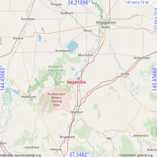
Nagambie GPS coordinates[2]
36° 47' 6.54" South, 145° 9' 13.5" East
| Map corner | latitude | longitude |
|---|---|---|
| Upper-left | -36.21996°, | 144.45063° |
| Center: | -36.78515°, | 145.15375° |
| Lower-right: | -37.3462°, | 145.85688° |
| Map W x H: | 125.2×125.2 km | = 77.8×77.8mi |
| max Lat: | -10.58257° ⇑81% North |
| Nagambie: | -36.78515° |
| min Lat: | ⇓19% South -43.31423° |
| min Long | Nagambie | max Long |
| 113.53327° | 145.15375° | 153.61246° |
| W 36.8%⇐ | ⇒63.2% E |
Elevation
Elevation of Nagambie is 132 m = 433 ft, and this is 10 m = 33 ft above average elevation for this country.
| Max E: |
1715 m = 5627 ft | 24.9% |
| Nagambie | 132 m 433 ft | |
| Avg. | 122 m = 400 ft | |
Min E: |
-2 m = -7 ft | 75.1% |
See also: Australia elevation on elevation.city.
Geographical zone
Nagambie is located in South temperate zone (between Tropic of Capricorn and the Antarctic Circle). Distance of this Southern Tropic circle is 1484.2 km =922.2 mi to North.| Distance of | km | miles | from Nagambie |
|---|---|---|---|
| Equator | 4090.1 | 2541.5 | to North |
| Tropic Capricorn | 1484.2 | 922.2 | to North |
| Antarctic Circle | 3311 | 2057.4 | to South |
| South Pole | 5916.9 | 3676.6 | to South |


Nearby cities:
15 places around Nagambie: (largest is in red/bold)
• Avenel
14.7 km =9.1 mi,  151°
151°
• Euroa
37.3 km =23.2 mi,  84°
84°
• Heathcote
42.5 km =26.4 mi,  248°
248°
• Kialla
44.2 km =27.5 mi,  31°
31°
• Merrigum
45.9 km =28.5 mi,  357°
357°
• Mooroopna
46.3 km =28.8 mi,  22°
22°
• Murchison
19.3 km =12 mi, 17°
• Puckapunyal
25.4 km =15.8 mi,  203°
203°
• Pyalong
45.2 km =28.1 mi,  216°
216°
• Rushworth
25.2 km =15.7 mi,  331°
331°
• Seymour
26.9 km =16.7 mi,  182°
182°
• Stanhope
40.6 km =25.2 mi,  337°
337°
• Tallarook
34.6 km =21.5 mi,  187°
187°
• Tatura
39 km =24.2 mi,  10°
10°
• Toolamba
36.2 km =22.5 mi, 28°
Sources, notices
• [Note1] Compared only with cities in Australia existing in our database
• [Src1] Map data: © OpenStreetMap contributors (CC-BY-SA)
• [Src2] Other city data from geonames.org with taken over terms of usage.
• [Src3] Geographical zone / Annual Mean Temperature by Robert A. Rohde @ Wikipedia
