Avenel geodata
Avenel (Victoria) is a populated place; located in Australia in Australia/Melbourne (GMT+11) time zone. With population of 1,004 people, there are 3814 cities with bigger population in this country. Compared to other cities in Australia, 81.3% of cities are located further ↑North; 62.2% of cities are located further →East and 78.1% of cities have lower elevation than Avenel. Note1


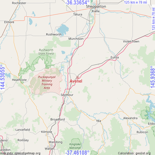
Avenel GPS coordinates[2]
36° 54' 3.168" South, 145° 14' 1.212" East
| Map corner | latitude | longitude |
|---|---|---|
| Upper-left | -36.33654°, | 144.53055° |
| Center: | -36.90088°, | 145.23367° |
| Lower-right: | -37.46108°, | 145.9368° |
| Map W x H: | 125×125 km | = 77.7×77.7mi |
| max Lat: | -10.58257° ⇑81.3% North |
| Avenel: | -36.90088° |
| min Lat: | ⇓18.7% South -43.31423° |
| min Long | Avenel | max Long |
| 113.53327° | 145.23367° | 153.61246° |
| W 37.8%⇐ | ⇒62.2% E |
Elevation
Elevation of Avenel is 157 m = 515 ft, and this is 35 m = 115 ft above average elevation for this country.
| Max E: |
1715 m = 5627 ft | 21.9% |
| Avenel | 157 m 515 ft | |
| Avg. | 122 m = 400 ft | |
Min E: |
-2 m = -7 ft | 78.1% |
See also: Australia elevation on elevation.city.
Geographical zone
Avenel is located in South temperate zone (between Tropic of Capricorn and the Antarctic Circle). Distance of this Southern Tropic circle is 1497.1 km =930.3 mi to North.| Distance of | km | miles | from Avenel |
|---|---|---|---|
| Equator | 4103 | 2549.5 | to North |
| Tropic Capricorn | 1497.1 | 930.3 | to North |
| Antarctic Circle | 3298.2 | 2049.4 | to South |
| South Pole | 5904.1 | 3668.6 | to South |


Nearby cities:
15 places around Avenel: (largest is in red/bold)
• Broadford
37.4 km =23.2 mi,  206°
206°
• Euroa
34.1 km =21.2 mi,  61°
61°
• Flowerdale
48.9 km =30.4 mi,  169°
169°
• Heathcote
46.8 km =29.1 mi,  267°
267°
• Kilmore
50.5 km =31.4 mi, 209°
• Murchison
31.4 km =19.5 mi,  357°
357°
• Nagambie
14.7 km =9.1 mi,  331°
331°
• Puckapunyal
20.1 km =12.5 mi,  238°
238°
• Pyalong
41.3 km =25.7 mi, 235°
• Rushworth
39.9 km =24.8 mi, 331°
• Seymour
16.3 km =10.1 mi, 210°
• Tallarook
24.5 km =15.2 mi, 208°
• Tatura
51.3 km =31.9 mi, 359°
• Toolamba
45.8 km =28.5 mi,  13°
13°
• Yea
38.5 km =23.9 mi,  153°
153°
Sources, notices
• [Note1] Compared only with cities in Australia existing in our database
• [Src1] Map data: © OpenStreetMap contributors (CC-BY-SA)
• [Src2] Other city data from geonames.org with taken over terms of usage.
• [Src3] Geographical zone / Annual Mean Temperature by Robert A. Rohde @ Wikipedia
