Oberon geodata
Oberon (New South Wales) is a populated place; located in Australia in Australia/Sydney (GMT+11) time zone. With population of 3,234 people, there are 2102 cities with bigger population in this country. Compared to other cities in Australia, 51.1% of cities are located further ↓South; 56.7% of cities are located further ←West and 99.9% of cities have lower elevation than Oberon. Note1


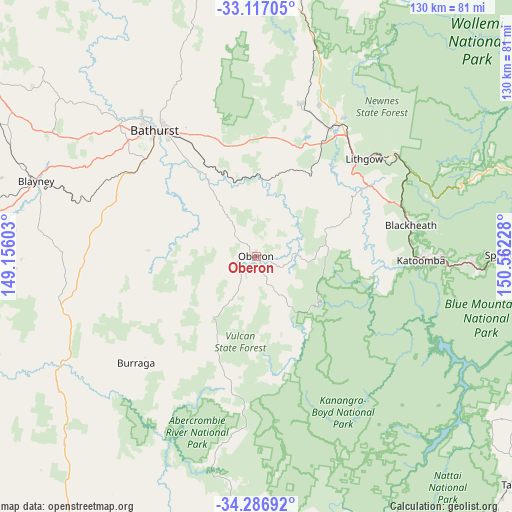
Oberon GPS coordinates[2]
33° 42' 14.328" South, 149° 51' 32.94" East
| Map corner | latitude | longitude |
|---|---|---|
| Upper-left | -33.11705°, | 149.15603° |
| Center: | -33.70398°, | 149.85915° |
| Lower-right: | -34.28692°, | 150.56228° |
| Map W x H: | 130.1×130.1 km | = 80.8×80.8mi |
| max Lat: | -10.58257° ⇑48.9% North |
| Oberon: | -33.70398° |
| min Lat: | ⇓51.1% South -43.31423° |
| min Long | Oberon | max Long |
| 113.53327° | 149.85915° | 153.61246° |
| W 56.7%⇐ | ⇒43.3% E |
Elevation
Elevation of Oberon is 1104 m = 3622 ft, and this is 982 m = 3222 ft above average elevation for this country.
| Max E: |
1715 m = 5627 ft | 0.099999999999994% |
| Oberon | 1104 m 3622 ft | |
| Avg. | 122 m = 400 ft | |
Min E: |
-2 m = -7 ft | 99.9% |
See also: Australia elevation on elevation.city.
Geographical zone
Oberon is located in South temperate zone (between Tropic of Capricorn and the Antarctic Circle). Distance of this Southern Tropic circle is 1141.6 km =709.4 mi to North.| Distance of | km | miles | from Oberon |
|---|---|---|---|
| Equator | 3747.5 | 2328.6 | to North |
| Tropic Capricorn | 1141.6 | 709.4 | to North |
| Antarctic Circle | 3653.6 | 2270.2 | to South |
| South Pole | 6259.5 | 3889.5 | to South |


Nearby cities:
15 places around Oberon: (largest is in red/bold)
• Blackheath
40 km =24.9 mi,  79°
79°
• Bowenfels
35.4 km =22 mi,  46°
46°
• Gormans Hill
35.9 km =22.3 mi,  317°
317°
• Kelso
40 km =24.9 mi, 323°
• Lithgow
36.3 km =22.6 mi, 47°
• Littleton
34.8 km =21.6 mi, 48°
• Marrangaroo
38.4 km =23.9 mi,  38°
38°
• Medlow Bath
39 km =24.2 mi,  85°
85°
• Morts Estate
38.9 km =24.2 mi, 47°
• Mount Victoria
38.8 km =24.1 mi,  71°
71°
• Perthville
37.7 km =23.4 mi,  309°
309°
• Raglan
36.6 km =22.7 mi,  330°
330°
• South Bathurst
39.7 km =24.7 mi, 317°
• South Bowenfels
31.7 km =19.7 mi, 48°
• Wallerawang
37.7 km =23.4 mi,  30°
30°
Sources, notices
• [Note1] Compared only with cities in Australia existing in our database
• [Src1] Map data: © OpenStreetMap contributors (CC-BY-SA)
• [Src2] Other city data from geonames.org with taken over terms of usage.
• [Src3] Geographical zone / Annual Mean Temperature by Robert A. Rohde @ Wikipedia
