Portland geodata
Portland (New South Wales) is a populated place; located in Australia in Australia/Sydney (GMT+11) time zone. With population of 2,326 people, there are 2675 cities with bigger population in this country. Compared to other cities in Australia, 55% of cities are located further ↓South; 56.9% of cities are located further ←West and 99.5% of cities have lower elevation than Portland. Note1


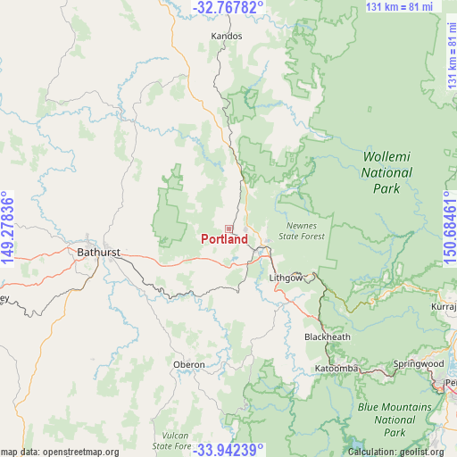
Portland GPS coordinates[2]
33° 21' 25.524" South, 149° 58' 53.328" East
| Map corner | latitude | longitude |
|---|---|---|
| Upper-left | -32.76782°, | 149.27836° |
| Center: | -33.35709°, | 149.98148° |
| Lower-right: | -33.94239°, | 150.68461° |
| Map W x H: | 130.6×130.6 km | = 81.2×81.2mi |
| max Lat: | -10.58257° ⇑45% North |
| Portland: | -33.35709° |
| min Lat: | ⇓55% South -43.31423° |
| min Long | Portland | max Long |
| 113.53327° | 149.98148° | 153.61246° |
| W 56.9%⇐ | ⇒43.1% E |
Elevation
Elevation of Portland is 941 m = 3087 ft, and this is 819 m = 2687 ft above average elevation for this country.
| Max E: |
1715 m = 5627 ft | 0.5% |
| Portland | 941 m 3087 ft | |
| Avg. | 122 m = 400 ft | |
Min E: |
-2 m = -7 ft | 99.5% |
See also: Australia elevation on elevation.city.
Geographical zone
Portland is located in South temperate zone (between Tropic of Capricorn and the Antarctic Circle). Distance of this Southern Tropic circle is 1103 km =685.4 mi to North.| Distance of | km | miles | from Portland |
|---|---|---|---|
| Equator | 3709 | 2304.7 | to North |
| Tropic Capricorn | 1103 | 685.4 | to North |
| Antarctic Circle | 3692.2 | 2294.2 | to South |
| South Pole | 6298.1 | 3913.5 | to South |


Nearby cities:
15 places around Portland: (largest is in red/bold)
• Bathurst
37.8 km =23.5 mi,  259°
259°
• Bathurst city centre
38.2 km =23.7 mi, 259°
• Bowenfels
20 km =12.4 mi,  134°
134°
• Gormans Hill
37.9 km =23.5 mi,  251°
251°
• Kelso
36 km =22.4 mi, 259°
• Lithgow
21 km =13 mi, 132°
• Littleton
21.3 km =13.2 mi,  136°
136°
• Marrangaroo
15.1 km =9.4 mi,  124°
124°
• Morts Estate
21.3 km =13.2 mi, 125°
• Mount Victoria
36.4 km =22.6 mi, 135°
• Raglan
30 km =18.6 mi, 257°
• South Bathurst
39.1 km =24.3 mi, 256°
• South Bowenfels
21.7 km =13.5 mi, 144°
• Wallerawang
9.8 km =6.1 mi, 127°
• West Bathurst
39.3 km =24.4 mi, 261°
Sources, notices
• [Note1] Compared only with cities in Australia existing in our database
• [Src1] Map data: © OpenStreetMap contributors (CC-BY-SA)
• [Src2] Other city data from geonames.org with taken over terms of usage.
• [Src3] Geographical zone / Annual Mean Temperature by Robert A. Rohde @ Wikipedia
