South Bowenfels geodata
South Bowenfels (New South Wales) is a populated place; located in Australia in Australia/Sydney (GMT+11) time zone. With population of 1,971 people, there are 2929 cities with bigger population in this country. Compared to other cities in Australia, 53.2% of cities are located further ↓South; 57.2% of cities are located further ←West and 99.3% of cities have lower elevation than South Bowenfels. Note1


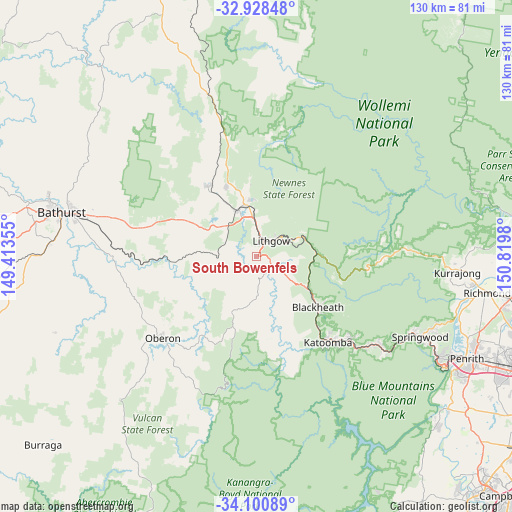
South Bowenfels GPS coordinates[2]
33° 31' 0.012" South, 150° 7' 0.012" East
| Map corner | latitude | longitude |
|---|---|---|
| Upper-left | -32.92848°, | 149.41355° |
| Center: | -33.51667°, | 150.11667° |
| Lower-right: | -34.10089°, | 150.8198° |
| Map W x H: | 130.4×130.4 km | = 81×81mi |
| max Lat: | -10.58257° ⇑46.8% North |
| South Bowenfels: | -33.51667° |
| min Lat: | ⇓53.2% South -43.31423° |
| min Long | South Bowenfels | max Long |
| 113.53327° | 150.11667° | 153.61246° |
| W 57.2%⇐ | ⇒42.8% E |
Elevation
Elevation of South Bowenfels is 890 m = 2920 ft, and this is 768 m = 2520 ft above average elevation for this country.
| Max E: |
1715 m = 5627 ft | 0.7% |
| South Bowenfels | 890 m 2920 ft | |
| Avg. | 122 m = 400 ft | |
Min E: |
-2 m = -7 ft | 99.3% |
See also: Australia elevation on elevation.city.
Geographical zone
South Bowenfels is located in South temperate zone (between Tropic of Capricorn and the Antarctic Circle). Distance of this Southern Tropic circle is 1120.8 km =696.4 mi to North.| Distance of | km | miles | from South Bowenfels |
|---|---|---|---|
| Equator | 3726.7 | 2315.7 | to North |
| Tropic Capricorn | 1120.8 | 696.4 | to North |
| Antarctic Circle | 3674.5 | 2283.2 | to South |
| South Pole | 6280.4 | 3902.5 | to South |


Nearby cities:
15 places around South Bowenfels: (largest is in red/bold)
• Blackheath
20.3 km =12.6 mi,  130°
130°
• Bowenfels
4.1 km =2.5 mi,  23°
23°
• Bullaburra
36.5 km =22.7 mi, 130°
• Katoomba
28.7 km =17.8 mi,  141°
141°
• Leura
29.9 km =18.6 mi, 137°
• Lithgow
4.7 km =2.9 mi,  39°
39°
• Littleton
3.2 km =2 mi, 42°
• Marrangaroo
9.3 km =5.8 mi,  0°
0°
• Medlow Bath
23.1 km =14.4 mi, 139°
• Morts Estate
7.3 km =4.5 mi, 41°
• Mount Victoria
15.3 km =9.5 mi,  122°
122°
• Oberon
31.7 km =19.7 mi,  228°
228°
• Portland
21.7 km =13.5 mi,  324°
324°
• Wallerawang
12.7 km =7.9 mi,  337°
337°
• Wentworth Falls
32.2 km =20 mi, 131°
Sources, notices
• [Note1] Compared only with cities in Australia existing in our database
• [Src1] Map data: © OpenStreetMap contributors (CC-BY-SA)
• [Src2] Other city data from geonames.org with taken over terms of usage.
• [Src3] Geographical zone / Annual Mean Temperature by Robert A. Rohde @ Wikipedia
