Littleton geodata
Littleton (New South Wales) is a populated place; located in Australia in Australia/Sydney (GMT+11) time zone. With population of 766 people, there are 4213 cities with bigger population in this country. Compared to other cities in Australia, 53.4% of cities are located further ↓South; 57.3% of cities are located further ←West and 99.5% of cities have lower elevation than Littleton. Note1


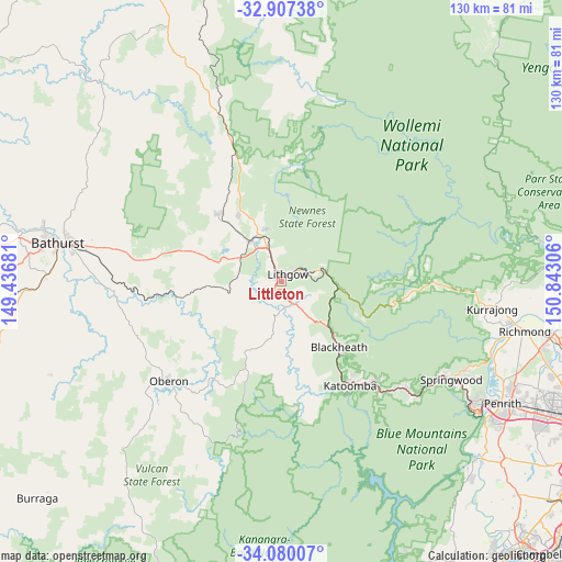
Littleton GPS coordinates[2]
33° 29' 44.556" South, 150° 8' 23.748" East
| Map corner | latitude | longitude |
|---|---|---|
| Upper-left | -32.90738°, | 149.43681° |
| Center: | -33.49571°, | 150.13993° |
| Lower-right: | -34.08007°, | 150.84306° |
| Map W x H: | 130.4×130.4 km | = 81×81mi |
| max Lat: | -10.58257° ⇑46.6% North |
| Littleton: | -33.49571° |
| min Lat: | ⇓53.4% South -43.31423° |
| min Long | Littleton | max Long |
| 113.53327° | 150.13993° | 153.61246° |
| W 57.3%⇐ | ⇒42.7% E |
Elevation
Elevation of Littleton is 945 m = 3100 ft, and this is 823 m = 2700 ft above average elevation for this country.
| Max E: |
1715 m = 5627 ft | 0.5% |
| Littleton | 945 m 3100 ft | |
| Avg. | 122 m = 400 ft | |
Min E: |
-2 m = -7 ft | 99.5% |
See also: Australia elevation on elevation.city.
Geographical zone
Littleton is located in South temperate zone (between Tropic of Capricorn and the Antarctic Circle). Distance of this Southern Tropic circle is 1118.5 km =695 mi to North.| Distance of | km | miles | from Littleton |
|---|---|---|---|
| Equator | 3724.4 | 2314.2 | to North |
| Tropic Capricorn | 1118.5 | 695 | to North |
| Antarctic Circle | 3676.8 | 2284.7 | to South |
| South Pole | 6282.7 | 3903.9 | to South |


Nearby cities:
15 places around Littleton: (largest is in red/bold)
• Bilpin
36.5 km =22.7 mi,  90°
90°
• Blackheath
20.5 km =12.7 mi,  139°
139°
• Bowenfels
1.5 km =0.9 mi,  339°
339°
• Katoomba
29.3 km =18.2 mi,  148°
148°
• Leura
30.4 km =18.9 mi, 143°
• Lithgow
1.5 km =0.9 mi,  34°
34°
• Marrangaroo
7.3 km =4.5 mi, 342°
• Medlow Bath
23.7 km =14.7 mi, 147°
• Morts Estate
4.1 km =2.5 mi,  40°
40°
• Mount Victoria
15.1 km =9.4 mi,  134°
134°
• Oberon
34.8 km =21.6 mi,  228°
228°
• Portland
21.3 km =13.2 mi,  316°
316°
• South Bowenfels
3.2 km =2 mi,  222°
222°
• Wallerawang
11.7 km =7.3 mi, 323°
• Wentworth Falls
32.3 km =20.1 mi, 137°
Sources, notices
• [Note1] Compared only with cities in Australia existing in our database
• [Src1] Map data: © OpenStreetMap contributors (CC-BY-SA)
• [Src2] Other city data from geonames.org with taken over terms of usage.
• [Src3] Geographical zone / Annual Mean Temperature by Robert A. Rohde @ Wikipedia
