Wallerawang geodata
Wallerawang (New South Wales) is a populated place; located in Australia in Australia/Sydney (GMT+11) time zone. With population of 1,943 people, there are 2945 cities with bigger population in this country. Compared to other cities in Australia, 54.4% of cities are located further ↓South; 57.1% of cities are located further ←West and 99.3% of cities have lower elevation than Wallerawang. Note1


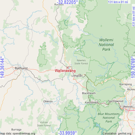
Wallerawang GPS coordinates[2]
33° 24' 39.456" South, 150° 3' 52.416" East
| Map corner | latitude | longitude |
|---|---|---|
| Upper-left | -32.82205°, | 149.36144° |
| Center: | -33.41096°, | 150.06456° |
| Lower-right: | -33.9959°, | 150.76769° |
| Map W x H: | 130.5×130.5 km | = 81.1×81.1mi |
| max Lat: | -10.58257° ⇑45.6% North |
| Wallerawang: | -33.41096° |
| min Lat: | ⇓54.4% South -43.31423° |
| min Long | Wallerawang | max Long |
| 113.53327° | 150.06456° | 153.61246° |
| W 57.1%⇐ | ⇒42.9% E |
Elevation
Elevation of Wallerawang is 897 m = 2943 ft, and this is 775 m = 2543 ft above average elevation for this country.
| Max E: |
1715 m = 5627 ft | 0.7% |
| Wallerawang | 897 m 2943 ft | |
| Avg. | 122 m = 400 ft | |
Min E: |
-2 m = -7 ft | 99.3% |
See also: Australia elevation on elevation.city.
Geographical zone
Wallerawang is located in South temperate zone (between Tropic of Capricorn and the Antarctic Circle). Distance of this Southern Tropic circle is 1109 km =689.1 mi to North.| Distance of | km | miles | from Wallerawang |
|---|---|---|---|
| Equator | 3715 | 2308.4 | to North |
| Tropic Capricorn | 1109 | 689.1 | to North |
| Antarctic Circle | 3686.2 | 2290.5 | to South |
| South Pole | 6292.1 | 3909.7 | to South |


Nearby cities:
15 places around Wallerawang: (largest is in red/bold)
• Blackheath
32.2 km =20 mi,  140°
140°
• Bowenfels
10.3 km =6.4 mi, 141°
• Katoomba
41.1 km =25.5 mi,  146°
146°
• Kelso
43.1 km =26.8 mi,  269°
269°
• Leura
42.1 km =26.2 mi, 143°
• Lithgow
11.3 km =7 mi, 136°
• Littleton
11.7 km =7.3 mi, 143°
• Marrangaroo
5.4 km =3.4 mi,  117°
117°
• Medlow Bath
35.4 km =22 mi, 145°
• Morts Estate
11.6 km =7.2 mi, 123°
• Mount Victoria
26.7 km =16.6 mi, 138°
• Oberon
37.7 km =23.4 mi,  210°
210°
• Portland
9.8 km =6.1 mi,  307°
307°
• Raglan
36.9 km =22.9 mi, 269°
• South Bowenfels
12.7 km =7.9 mi,  157°
157°
Sources, notices
• [Note1] Compared only with cities in Australia existing in our database
• [Src1] Map data: © OpenStreetMap contributors (CC-BY-SA)
• [Src2] Other city data from geonames.org with taken over terms of usage.
• [Src3] Geographical zone / Annual Mean Temperature by Robert A. Rohde @ Wikipedia
