Orbost geodata
Orbost (Victoria) is a populated place; located in Australia in Australia/Melbourne (GMT+11) time zone. With population of 2,164 people, there are 2783 cities with bigger population in this country. Compared to other cities in Australia, 84.7% of cities are located further ↑North; 51.6% of cities are located further ←West and 53.1% of cities have higher elevation than Orbost. Note1


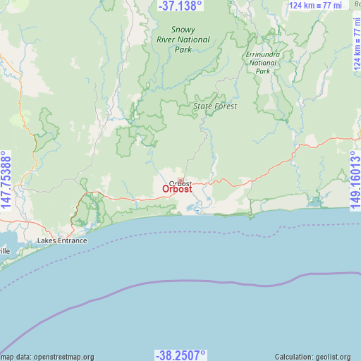
Orbost GPS coordinates[2]
37° 41' 47.184" South, 148° 27' 25.2" East
| Map corner | latitude | longitude |
|---|---|---|
| Upper-left | -37.138°, | 147.75388° |
| Center: | -37.69644°, | 148.457° |
| Lower-right: | -38.2507°, | 149.16013° |
| Map W x H: | 123.7×123.7 km | = 76.9×76.9mi |
| max Lat: | -10.58257° ⇑84.7% North |
| Orbost: | -37.69644° |
| min Lat: | ⇓15.3% South -43.31423° |
| min Long | Orbost | max Long |
| 113.53327° | 148.457° | 153.61246° |
| W 51.6%⇐ | ⇒48.4% E |
Elevation
Elevation of Orbost is 41 m = 135 ft, and this is 81 m = 266 ft below average elevation for this country.
| Max E: |
1715 m = 5627 ft | 53.1% |
| Avg. | 122 m = 400 ft | |
| Orbost | 41 m = 135 ft | |
Min E: |
-2 m = -7 ft | 46.9% |
See also: Australia elevation on elevation.city.
Geographical zone
Orbost is located in South temperate zone (between Tropic of Capricorn and the Antarctic Circle). Distance of this Southern Tropic circle is 1585.5 km =985.2 mi to North.| Distance of | km | miles | from Orbost |
|---|---|---|---|
| Equator | 4191.5 | 2604.5 | to North |
| Tropic Capricorn | 1585.5 | 985.2 | to North |
| Antarctic Circle | 3209.7 | 1994.4 | to South |
| South Pole | 5815.6 | 3613.6 | to South |


Nearby cities:
15 places around Orbost: (largest is in red/bold)
• Bairnsdale
75.7 km =47 mi,  259°
259°
• Bruthen
55.1 km =34.2 mi,  268°
268°
• Eagle Point
71.6 km =44.5 mi,  251°
251°
• East Bairnsdale
72.1 km =44.8 mi, 257°
• Kalimna
47.2 km =29.3 mi, 245°
• Lake Tyers Beach
38.7 km =24 mi,  241°
241°
• Lakes Entrance
44.3 km =27.5 mi, 244°
• Lucknow
72.2 km =44.9 mi, 259°
• Marlo
12.9 km =8 mi,  149°
149°
• Metung
57.3 km =35.6 mi, 247°
• Newlands Arm
72 km =44.7 mi, 248°
• Nicholson
65 km =40.4 mi, 258°
• Paynesville
69.4 km =43.1 mi, 249°
• Sarsfield
65.4 km =40.6 mi, 264°
• Swan Reach
54.1 km =33.6 mi, 253°
Sources, notices
• [Note1] Compared only with cities in Australia existing in our database
• [Src1] Map data: © OpenStreetMap contributors (CC-BY-SA)
• [Src2] Other city data from geonames.org with taken over terms of usage.
• [Src3] Geographical zone / Annual Mean Temperature by Robert A. Rohde @ Wikipedia
