Marlo geodata
Marlo (Victoria) is a populated place; located in Australia in Australia/Melbourne (GMT+11) time zone. With population of 520 people, there are 4816 cities with bigger population in this country. Compared to other cities in Australia, 87.3% of cities are located further ↑North; 51.7% of cities are located further ←West and 68.6% of cities have higher elevation than Marlo. Note1


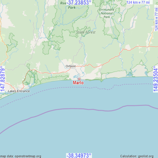
Marlo GPS coordinates[2]
37° 47' 46.392" South, 148° 31' 54.876" East
| Map corner | latitude | longitude |
|---|---|---|
| Upper-left | -37.23853°, | 147.82879° |
| Center: | -37.79622°, | 148.53191° |
| Lower-right: | -38.34973°, | 149.23504° |
| Map W x H: | 123.6×123.6 km | = 76.8×76.8mi |
| max Lat: | -10.58257° ⇑87.3% North |
| Marlo: | -37.79622° |
| min Lat: | ⇓12.7% South -43.31423° |
| min Long | Marlo | max Long |
| 113.53327° | 148.53191° | 153.61246° |
| W 51.7%⇐ | ⇒48.3% E |
Elevation
Elevation of Marlo is 24 m = 79 ft, and this is 98 m = 322 ft below average elevation for this country.
| Max E: |
1715 m = 5627 ft | 68.6% |
| Avg. | 122 m = 400 ft | |
| Marlo | 24 m = 79 ft | |
Min E: |
-2 m = -7 ft | 31.4% |
See also: Australia elevation on elevation.city.
Geographical zone
Marlo is located in South temperate zone (between Tropic of Capricorn and the Antarctic Circle). Distance of this Southern Tropic circle is 1596.6 km =992.1 mi to North.| Distance of | km | miles | from Marlo |
|---|---|---|---|
| Equator | 4202.5 | 2611.3 | to North |
| Tropic Capricorn | 1596.6 | 992.1 | to North |
| Antarctic Circle | 3198.6 | 1987.5 | to South |
| South Pole | 5804.5 | 3606.7 | to South |


Nearby cities:
15 places around Marlo: (largest is in red/bold)
• Bairnsdale
81 km =50.3 mi,  267°
267°
• Bruthen
62.4 km =38.8 mi,  279°
279°
• Eagle Point
75.4 km =46.9 mi,  261°
261°
• East Bairnsdale
77.1 km =47.9 mi, 266°
• Kalimna
50.3 km =31.3 mi, 260°
• Lake Tyers Beach
41.3 km =25.7 mi, 259°
• Lakes Entrance
47.2 km =29.3 mi, 260°
• Lucknow
77.5 km =48.2 mi, 268°
• Metung
60.5 km =37.6 mi, 259°
• Newlands Arm
75.2 km =46.7 mi, 258°
• Nicholson
70.2 km =43.6 mi, 268°
• Orbost
12.9 km =8 mi,  329°
329°
• Paynesville
72.6 km =45.1 mi, 259°
• Sarsfield
71.8 km =44.6 mi, 274°
• Swan Reach
58.6 km =36.4 mi, 265°
Sources, notices
• [Note1] Compared only with cities in Australia existing in our database
• [Src1] Map data: © OpenStreetMap contributors (CC-BY-SA)
• [Src2] Other city data from geonames.org with taken over terms of usage.
• [Src3] Geographical zone / Annual Mean Temperature by Robert A. Rohde @ Wikipedia
