Oakleigh geodata
Oakleigh (Victoria) is a section of populated place; located in Australia in Australia/Melbourne (GMT+11) time zone. With population of 7,822 people, there are 859 cities with bigger population in this country. Compared to other cities in Australia, 90.3% of cities are located further ↑North; 64.6% of cities are located further →East and 60.3% of cities have lower elevation than Oakleigh. Note1


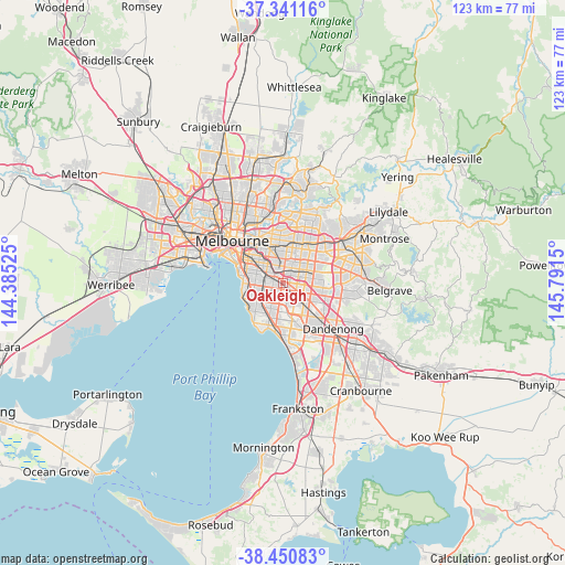
Oakleigh GPS coordinates[2]
37° 53' 53.124" South, 145° 5' 18.132" East
| Map corner | latitude | longitude |
|---|---|---|
| Upper-left | -37.34116°, | 144.38525° |
| Center: | -37.89809°, | 145.08837° |
| Lower-right: | -38.45083°, | 145.7915° |
| Map W x H: | 123.4×123.4 km | = 76.7×76.7mi |
| max Lat: | -10.58257° ⇑90.3% North |
| Oakleigh: | -37.89809° |
| min Lat: | ⇓9.7% South -43.31423° |
| min Long | Oakleigh | max Long |
| 113.53327° | 145.08837° | 153.61246° |
| W 35.4%⇐ | ⇒64.6% E |
Elevation
Elevation of Oakleigh is 65 m = 213 ft, and this is 57 m = 187 ft below average elevation for this country.
| Max E: |
1715 m = 5627 ft | 39.7% |
| Avg. | 122 m = 400 ft | |
| Oakleigh | 65 m = 213 ft | |
Min E: |
-2 m = -7 ft | 60.3% |
See also: Australia elevation on elevation.city.
Geographical zone
Oakleigh is located in South temperate zone (between Tropic of Capricorn and the Antarctic Circle). Distance of this Southern Tropic circle is 1608 km =999.2 mi to North.| Distance of | km | miles | from Oakleigh |
|---|---|---|---|
| Equator | 4213.9 | 2618.4 | to North |
| Tropic Capricorn | 1608 | 999.2 | to North |
| Antarctic Circle | 3187.3 | 1980.5 | to South |
| South Pole | 5793.2 | 3599.7 | to South |


Nearby cities:
15 places around Oakleigh: (largest is in red/bold)
• Ashburton
3.5 km =2.2 mi,  352°
352°
• Ashwood
3.8 km =2.4 mi,  23°
23°
• Bentleigh East
3.9 km =2.4 mi,  232°
232°
• Carnegie
2.9 km =1.8 mi,  279°
279°
• Chadstone
1.3 km =0.8 mi,  27°
27°
• Clayton
3.2 km =2 mi,  129°
129°
• Glen Huntly
4.2 km =2.6 mi, 278°
• Glen Iris
4 km =2.5 mi,  331°
331°
• Hughesdale
0.5 km =0.3 mi,  244°
244°
• Huntingdale
2.1 km =1.3 mi,  121°
121°
• McKinnon
3.9 km =2.4 mi, 238°
• Mount Waverley
4.3 km =2.7 mi,  57°
57°
• Murrumbeena
1.9 km =1.2 mi,  263°
263°
• Oakleigh East
2.5 km =1.6 mi,  94°
94°
• Oakleigh South
2.9 km =1.8 mi,  174°
174°
Sources, notices
• [Note1] Compared only with cities in Australia existing in our database
• [Src1] Map data: © OpenStreetMap contributors (CC-BY-SA)
• [Src2] Other city data from geonames.org with taken over terms of usage.
• [Src3] Geographical zone / Annual Mean Temperature by Robert A. Rohde @ Wikipedia
