Carnegie geodata
Carnegie (Victoria) is a section of populated place; located in Australia in Australia/Melbourne (GMT+11) time zone. With population of 17,121 people, there are 214 cities with bigger population in this country. Compared to other cities in Australia, 90.2% of cities are located further ↑North; 65.2% of cities are located further →East and 55% of cities have lower elevation than Carnegie. Note1


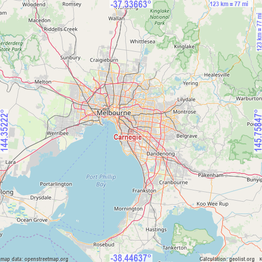
Carnegie GPS coordinates[2]
37° 53' 36.924" South, 145° 3' 19.224" East
| Map corner | latitude | longitude |
|---|---|---|
| Upper-left | -37.33663°, | 144.35222° |
| Center: | -37.89359°, | 145.05534° |
| Lower-right: | -38.44637°, | 145.75847° |
| Map W x H: | 123.4×123.4 km | = 76.7×76.7mi |
| max Lat: | -10.58257° ⇑90.2% North |
| Carnegie: | -37.89359° |
| min Lat: | ⇓9.8% South -43.31423° |
| min Long | Carnegie | max Long |
| 113.53327° | 145.05534° | 153.61246° |
| W 34.8%⇐ | ⇒65.2% E |
Elevation
Elevation of Carnegie is 53 m = 174 ft, and this is 69 m = 226 ft below average elevation for this country.
| Max E: |
1715 m = 5627 ft | 45% |
| Avg. | 122 m = 400 ft | |
| Carnegie | 53 m = 174 ft | |
Min E: |
-2 m = -7 ft | 55% |
See also: Australia elevation on elevation.city.
Geographical zone
Carnegie is located in South temperate zone (between Tropic of Capricorn and the Antarctic Circle). Distance of this Southern Tropic circle is 1607.5 km =998.9 mi to North.| Distance of | km | miles | from Carnegie |
|---|---|---|---|
| Equator | 4213.4 | 2618.1 | to North |
| Tropic Capricorn | 1607.5 | 998.9 | to North |
| Antarctic Circle | 3187.8 | 1980.8 | to South |
| South Pole | 5793.7 | 3600 | to South |


Nearby cities:
15 places around Carnegie: (largest is in red/bold)
• Bentleigh
3.2 km =2 mi,  212°
212°
• Bentleigh East
2.9 km =1.8 mi,  184°
184°
• Brighton East
3.5 km =2.2 mi,  253°
253°
• Caulfield
3.1 km =1.9 mi,  293°
293°
• Caulfield East
1.8 km =1.1 mi,  319°
319°
• Caulfield North
3.5 km =2.2 mi,  309°
309°
• Caulfield South
2.6 km =1.6 mi,  264°
264°
• Glen Huntly
1.2 km =0.7 mi,  276°
276°
• Glen Iris
3.2 km =2 mi,  18°
18°
• Hughesdale
2.6 km =1.6 mi,  106°
106°
• Malvern East
2.5 km =1.6 mi,  332°
332°
• McKinnon
2.6 km =1.6 mi,  190°
190°
• Murrumbeena
1.2 km =0.7 mi,  125°
125°
• Oakleigh
2.9 km =1.8 mi,  99°
99°
• Ormond
2.1 km =1.3 mi, 249°
Sources, notices
• [Note1] Compared only with cities in Australia existing in our database
• [Src1] Map data: © OpenStreetMap contributors (CC-BY-SA)
• [Src2] Other city data from geonames.org with taken over terms of usage.
• [Src3] Geographical zone / Annual Mean Temperature by Robert A. Rohde @ Wikipedia
