Narangba geodata
Narangba (Queensland) is a populated place; located in Australia in Australia/Brisbane (GMT+10) time zone. With population of 18,217 people, there are 192 cities with bigger population in this country. Compared to other cities in Australia, 85.1% of cities are located further ↓South; 89.9% of cities are located further ←West and 52% of cities have lower elevation than Narangba. Note1


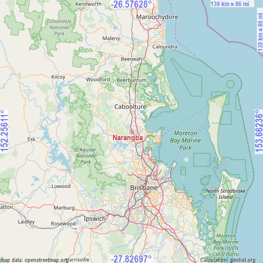
Narangba GPS coordinates[2]
27° 12' 12.168" South, 152° 57' 33.228" East
| Map corner | latitude | longitude |
|---|---|---|
| Upper-left | -26.57628°, | 152.25611° |
| Center: | -27.20338°, | 152.95923° |
| Lower-right: | -27.82697°, | 153.66236° |
| Map W x H: | 139.1×139.1 km | = 86.4×86.4mi |
| max Lat: | -10.58257° ⇑14.9% North |
| Narangba: | -27.20338° |
| min Lat: | ⇓85.1% South -43.31423° |
| min Long | Narangba | max Long |
| 113.53327° | 152.95923° | 153.61246° |
| W 89.9%⇐ | ⇒10.1% E |
Elevation
Elevation of Narangba is 48 m = 157 ft, and this is 74 m = 243 ft below average elevation for this country.
| Max E: |
1715 m = 5627 ft | 48% |
| Avg. | 122 m = 400 ft | |
| Narangba | 48 m = 157 ft | |
Min E: |
-2 m = -7 ft | 52% |
See also: Australia elevation on elevation.city.
Geographical zone
Narangba is located in South temperate zone (between Tropic of Capricorn and the Antarctic Circle). Distance of this Southern Tropic circle is 418.8 km =260.2 mi to North.| Distance of | km | miles | from Narangba |
|---|---|---|---|
| Equator | 3024.7 | 1879.5 | to North |
| Tropic Capricorn | 418.8 | 260.2 | to North |
| Antarctic Circle | 4376.4 | 2719.4 | to South |
| South Pole | 6982.3 | 4338.6 | to South |


Nearby cities:
15 places around Narangba: (largest is in red/bold)
• Bray Park
9.9 km =6.2 mi,  175°
175°
• Burpengary
5.1 km =3.2 mi,  358°
358°
• Burpengary East
7.7 km =4.8 mi,  31°
31°
• Dakabin
4 km =2.5 mi,  128°
128°
• Deception Bay
6.7 km =4.2 mi,  80°
80°
• Joyner
8.2 km =5.1 mi,  190°
190°
• Kallangur
6.3 km =3.9 mi,  148°
148°
• Kurwongbah
3.6 km =2.2 mi, 152°
• Lawnton
9.2 km =5.7 mi,  164°
164°
• Mango Hill
7.8 km =4.8 mi,  124°
124°
• Murrumba Downs
8.7 km =5.4 mi,  144°
144°
• North Lakes
6.5 km =4 mi,  110°
110°
• Petrie
7.4 km =4.6 mi, 161°
• Rothwell
8.7 km =5.4 mi,  98°
98°
• Whiteside
7.6 km =4.7 mi,  218°
218°
Sources, notices
• [Note1] Compared only with cities in Australia existing in our database
• [Src1] Map data: © OpenStreetMap contributors (CC-BY-SA)
• [Src2] Other city data from geonames.org with taken over terms of usage.
• [Src3] Geographical zone / Annual Mean Temperature by Robert A. Rohde @ Wikipedia
