Burpengary geodata
Burpengary (Queensland) is a section of populated place; located in Australia in Australia/Brisbane (GMT+10) time zone. With population of 13,779 people, there are 323 cities with bigger population in this country. Compared to other cities in Australia, 85.2% of cities are located further ↓South; 89.8% of cities are located further ←West and 76.1% of cities have higher elevation than Burpengary. Note1


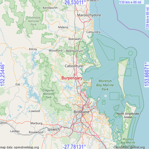
Burpengary GPS coordinates[2]
27° 9' 26.856" South, 152° 57' 27.288" East
| Map corner | latitude | longitude |
|---|---|---|
| Upper-left | -26.53011°, | 152.25446° |
| Center: | -27.15746°, | 152.95758° |
| Lower-right: | -27.78131°, | 153.66071° |
| Map W x H: | 139.1×139.1 km | = 86.4×86.4mi |
| max Lat: | -10.58257° ⇑14.8% North |
| Burpengary: | -27.15746° |
| min Lat: | ⇓85.2% South -43.31423° |
| min Long | Burpengary | max Long |
| 113.53327° | 152.95758° | 153.61246° |
| W 89.8%⇐ | ⇒10.2% E |
Elevation
Elevation of Burpengary is 18 m = 59 ft, and this is 104 m = 341 ft below average elevation for this country.
| Max E: |
1715 m = 5627 ft | 76.1% |
| Avg. | 122 m = 400 ft | |
| Burpengary | 18 m = 59 ft | |
Min E: |
-2 m = -7 ft | 23.9% |
See also: Australia elevation on elevation.city.
Geographical zone
Burpengary is located in South temperate zone (between Tropic of Capricorn and the Antarctic Circle). Distance of this Southern Tropic circle is 413.7 km =257.1 mi to North.| Distance of | km | miles | from Burpengary |
|---|---|---|---|
| Equator | 3019.6 | 1876.3 | to North |
| Tropic Capricorn | 413.7 | 257.1 | to North |
| Antarctic Circle | 4381.5 | 2722.5 | to South |
| South Pole | 6987.4 | 4341.8 | to South |


Nearby cities:
15 places around Burpengary: (largest is in red/bold)
• Beachmere
9.9 km =6.2 mi,  70°
70°
• Bellmere
10.5 km =6.5 mi,  320°
320°
• Burpengary East
4.4 km =2.7 mi, 70°
• Caboolture
8.1 km =5 mi,  355°
355°
• Caboolture South
7.1 km =4.4 mi,  352°
352°
• Dakabin
8.3 km =5.2 mi,  156°
156°
• Deception Bay
7.9 km =4.9 mi,  120°
120°
• Kallangur
11.1 km =6.9 mi, 161°
• Kurwongbah
8.5 km =5.3 mi,  167°
167°
• Mango Hill
11.6 km =7.2 mi,  145°
145°
• Morayfield
5.5 km =3.4 mi, 351°
• Narangba
5.1 km =3.2 mi,  178°
178°
• North Lakes
9.7 km =6 mi,  139°
139°
• Rothwell
10.9 km =6.8 mi,  125°
125°
• Upper Caboolture
8.6 km =5.3 mi,  301°
301°
Sources, notices
• [Note1] Compared only with cities in Australia existing in our database
• [Src1] Map data: © OpenStreetMap contributors (CC-BY-SA)
• [Src2] Other city data from geonames.org with taken over terms of usage.
• [Src3] Geographical zone / Annual Mean Temperature by Robert A. Rohde @ Wikipedia
