Lucinda geodata
Lucinda (Queensland) is a populated place; located in Australia in Australia/Brisbane (GMT+10) time zone. With population of 649 people, there are 4444 cities with bigger population in this country. Compared to other cities in Australia, 96% of cities are located further ↓South; 55.9% of cities are located further →East and 93.8% of cities have higher elevation than Lucinda. Note1


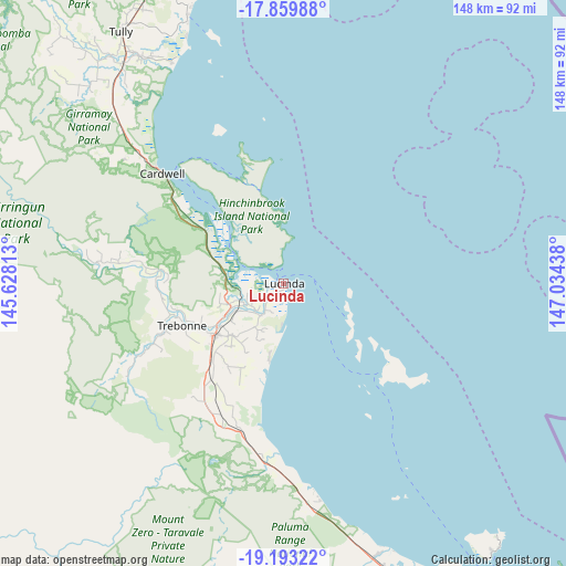
Lucinda GPS coordinates[2]
18° 31' 40.26" South, 146° 19' 52.5" East
| Map corner | latitude | longitude |
|---|---|---|
| Upper-left | -17.85988°, | 145.62813° |
| Center: | -18.52785°, | 146.33125° |
| Lower-right: | -19.19322°, | 147.03438° |
| Map W x H: | 148.3×148.3 km | = 92.1×92.1mi |
| max Lat: | -10.58257° ⇑4% North |
| Lucinda: | -18.52785° |
| min Lat: | ⇓96% South -43.31423° |
| min Long | Lucinda | max Long |
| 113.53327° | 146.33125° | 153.61246° |
| W 44.1%⇐ | ⇒55.9% E |
Elevation
Elevation of Lucinda is 7 m = 23 ft, and this is 115 m = 377 ft below average elevation for this country.
| Max E: |
1715 m = 5627 ft | 93.8% |
| Avg. | 122 m = 400 ft | |
| Lucinda | 7 m = 23 ft | |
Min E: |
-2 m = -7 ft | 6.2% |
See also: Australia elevation on elevation.city.
Geographical zone
Lucinda is located in South Torrid zone (between Equator and Tropic of Capricorn). Distance of this Southern Tropic circle is 545.8 km =339.1 mi to South.| Distance of | km | miles | from Lucinda |
|---|---|---|---|
| Equator | 2060.1 | 1280.1 | to North |
| Tropic Capricorn | 545.8 | 339.1 | to South |
| Antarctic Circle | 5341.1 | 3318.8 | to South |
| South Pole | 7947 | 4938 | to South |


Nearby cities:
15 places around Lucinda: (largest is in red/bold)
• Balgal Beach
54.9 km =34.1 mi,  171°
171°
• Black River
83.2 km =51.7 mi,  158°
158°
• Bluewater
76.5 km =47.5 mi, 161°
• Bluewater Park
77.7 km =48.3 mi, 165°
• Bushland Beach
82.2 km =51.1 mi,  153°
153°
• Cardwell
43.2 km =26.8 mi,  312°
312°
• Horseshoe Bay
86 km =53.4 mi,  139°
139°
• Ingham
22.1 km =13.7 mi,  233°
233°
• Mission Beach
77.1 km =47.9 mi,  341°
341°
• Mount Low
86 km =53.4 mi, 155°
• Palm Island
34.8 km =21.6 mi,  131°
131°
• South Mission Beach
69.4 km =43.1 mi, 337°
• Tully
79 km =49.1 mi,  326°
326°
• Wongaling Beach
72.7 km =45.2 mi, 340°
• Yabulu
79.6 km =49.5 mi, 160°
Sources, notices
• [Note1] Compared only with cities in Australia existing in our database
• [Src1] Map data: © OpenStreetMap contributors (CC-BY-SA)
• [Src2] Other city data from geonames.org with taken over terms of usage.
• [Src3] Geographical zone / Annual Mean Temperature by Robert A. Rohde @ Wikipedia
