Balgal Beach geodata
Balgal Beach (Queensland) is a section of populated place; located in Australia in Australia/Brisbane (GMT+10) time zone. With population of 943 people, there are 3910 cities with bigger population in this country. Compared to other cities in Australia, 95.9% of cities are located further ↓South; 55.6% of cities are located further →East and 88.3% of cities have higher elevation than Balgal Beach. Note1


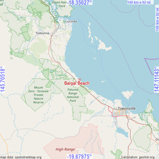
Balgal Beach GPS coordinates[2]
19° 0' 58.824" South, 146° 24' 29.88" East
| Map corner | latitude | longitude |
|---|---|---|
| Upper-left | -18.35027°, | 145.70518° |
| Center: | -19.01634°, | 146.4083° |
| Lower-right: | -19.67975°, | 147.11143° |
| Map W x H: | 147.8×147.8 km | = 91.8×91.8mi |
| max Lat: | -10.58257° ⇑4.1% North |
| Balgal Beach: | -19.01634° |
| min Lat: | ⇓95.9% South -43.31423° |
| min Long | Balgal Beach | max Long |
| 113.53327° | 146.4083° | 153.61246° |
| W 44.4%⇐ | ⇒55.6% E |
Elevation
Elevation of Balgal Beach is 10 m = 33 ft, and this is 112 m = 367 ft below average elevation for this country.
| Max E: |
1715 m = 5627 ft | 88.3% |
| Avg. | 122 m = 400 ft | |
| Balgal Beach | 10 m = 33 ft | |
Min E: |
-2 m = -7 ft | 11.7% |
See also: Australia elevation on elevation.city.
Geographical zone
Balgal Beach is located in South Torrid zone (between Equator and Tropic of Capricorn). Distance of this Southern Tropic circle is 491.5 km =305.4 mi to South.| Distance of | km | miles | from Balgal Beach |
|---|---|---|---|
| Equator | 2114.4 | 1313.8 | to North |
| Tropic Capricorn | 491.5 | 305.4 | to South |
| Antarctic Circle | 5286.8 | 3285.1 | to South |
| South Pole | 7892.6 | 4904.2 | to South |


Nearby cities:
15 places around Balgal Beach: (largest is in red/bold)
• Alice River
41.4 km =25.7 mi,  148°
148°
• Black River
32 km =19.9 mi,  136°
136°
• Bluewater
24.2 km =15 mi, 139°
• Bluewater Park
23.7 km =14.7 mi, 152°
• Bohle Plains
44.5 km =27.7 mi, 137°
• Burdell
40.1 km =24.9 mi,  130°
130°
• Bushland Beach
34.3 km =21.3 mi,  124°
124°
• Deeragun
38.1 km =23.7 mi, 132°
• Jensen
36.2 km =22.5 mi, 134°
• Mount Low
36.4 km =22.6 mi, 131°
• Pallarenda
43.5 km =27 mi, 118°
• Palm Island
35.9 km =22.3 mi,  29°
29°
• Rangewood
40.8 km =25.4 mi, 143°
• Shaw
41.4 km =25.7 mi, 131°
• Yabulu
27.9 km =17.3 mi, 137°
Sources, notices
• [Note1] Compared only with cities in Australia existing in our database
• [Src1] Map data: © OpenStreetMap contributors (CC-BY-SA)
• [Src2] Other city data from geonames.org with taken over terms of usage.
• [Src3] Geographical zone / Annual Mean Temperature by Robert A. Rohde @ Wikipedia
