Lorne geodata
Lorne (Victoria) is a populated place; located in Australia in Australia/Melbourne (GMT+11) time zone. With population of 1,196 people, there are 3589 cities with bigger population in this country. Compared to other cities in Australia, 96% of cities are located further ↑North; 72.5% of cities are located further →East and 58.5% of cities have lower elevation than Lorne. Note1


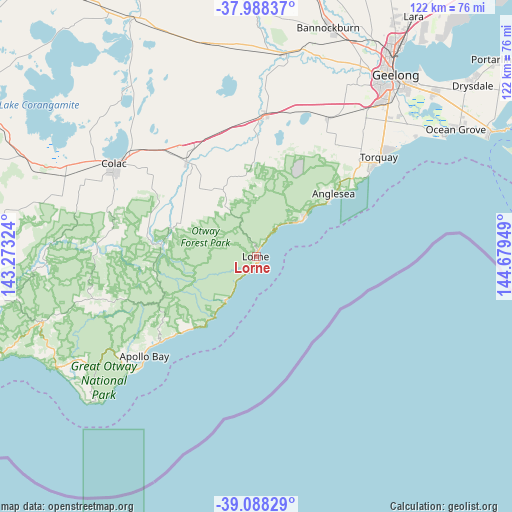
Lorne GPS coordinates[2]
38° 32' 25.548" South, 143° 58' 34.896" East
| Map corner | latitude | longitude |
|---|---|---|
| Upper-left | -37.98837°, | 143.27324° |
| Center: | -38.54043°, | 143.97636° |
| Lower-right: | -39.08829°, | 144.67949° |
| Map W x H: | 122.3×122.3 km | = 76×76mi |
| max Lat: | -10.58257° ⇑96% North |
| Lorne: | -38.54043° |
| min Lat: | ⇓4% South -43.31423° |
| min Long | Lorne | max Long |
| 113.53327° | 143.97636° | 153.61246° |
| W 27.5%⇐ | ⇒72.5% E |
Elevation
Elevation of Lorne is 60 m = 197 ft, and this is 62 m = 203 ft below average elevation for this country.
| Max E: |
1715 m = 5627 ft | 41.5% |
| Avg. | 122 m = 400 ft | |
| Lorne | 60 m = 197 ft | |
Min E: |
-2 m = -7 ft | 58.5% |
See also: Australia elevation on elevation.city.
Geographical zone
Lorne is located in South temperate zone (between Tropic of Capricorn and the Antarctic Circle). Distance of this Southern Tropic circle is 1679.4 km =1043.5 mi to North.| Distance of | km | miles | from Lorne |
|---|---|---|---|
| Equator | 4285.3 | 2662.8 | to North |
| Tropic Capricorn | 1679.4 | 1043.5 | to North |
| Antarctic Circle | 3115.9 | 1936.1 | to South |
| South Pole | 5721.8 | 3555.4 | to South |


Nearby cities:
15 places around Lorne: (largest is in red/bold)
• Aireys Inlet
14 km =8.7 mi,  52°
52°
• Anglesea
23.5 km =14.6 mi, 50°
• Apollo Bay
35.9 km =22.3 mi,  227°
227°
• Armstrong Creek
48.8 km =30.3 mi, 45°
• Bellbrae
34.2 km =21.3 mi, 47°
• Birregurra
28.1 km =17.5 mi,  323°
323°
• Colac
40.8 km =25.4 mi,  303°
303°
• Connewarre
47.8 km =29.7 mi, 50°
• Elliminyt
39.3 km =24.4 mi, 298°
• Jan Juc
35.3 km =21.9 mi, 51°
• Moriac
37.5 km =23.3 mi,  27°
27°
• Mount Duneed
45.8 km =28.5 mi,  43°
43°
• Torquay
38.4 km =23.9 mi, 52°
• Waurn Ponds
44.9 km =27.9 mi, 36°
• Winchelsea
32.9 km =20.4 mi,  1°
1°
Sources, notices
• [Note1] Compared only with cities in Australia existing in our database
• [Src1] Map data: © OpenStreetMap contributors (CC-BY-SA)
• [Src2] Other city data from geonames.org with taken over terms of usage.
• [Src3] Geographical zone / Annual Mean Temperature by Robert A. Rohde @ Wikipedia
