Lockhart geodata
Lockhart (New South Wales) is a populated place; located in Australia in Australia/Sydney (GMT+11) time zone. With population of 1,030 people, there are 3783 cities with bigger population in this country. Compared to other cities in Australia, 74.6% of cities are located further ↑North; 54.8% of cities are located further →East and 78% of cities have lower elevation than Lockhart. Note1


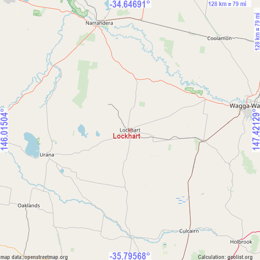
Lockhart GPS coordinates[2]
35° 13' 23.988" South, 146° 43' 5.376" East
| Map corner | latitude | longitude |
|---|---|---|
| Upper-left | -34.64691°, | 146.01504° |
| Center: | -35.22333°, | 146.71816° |
| Lower-right: | -35.79568°, | 147.42129° |
| Map W x H: | 127.7×127.7 km | = 79.3×79.3mi |
| max Lat: | -10.58257° ⇑74.6% North |
| Lockhart: | -35.22333° |
| min Lat: | ⇓25.4% South -43.31423° |
| min Long | Lockhart | max Long |
| 113.53327° | 146.71816° | 153.61246° |
| W 45.2%⇐ | ⇒54.8% E |
Elevation
Elevation of Lockhart is 156 m = 512 ft, and this is 34 m = 112 ft above average elevation for this country.
| Max E: |
1715 m = 5627 ft | 22% |
| Lockhart | 156 m 512 ft | |
| Avg. | 122 m = 400 ft | |
Min E: |
-2 m = -7 ft | 78% |
See also: Australia elevation on elevation.city.
Geographical zone
Lockhart is located in South temperate zone (between Tropic of Capricorn and the Antarctic Circle). Distance of this Southern Tropic circle is 1310.5 km =814.3 mi to North.| Distance of | km | miles | from Lockhart |
|---|---|---|---|
| Equator | 3916.5 | 2433.6 | to North |
| Tropic Capricorn | 1310.5 | 814.3 | to North |
| Antarctic Circle | 3484.7 | 2165.3 | to South |
| South Pole | 6090.6 | 3784.5 | to South |


Nearby cities:
15 places around Lockhart: (largest is in red/bold)
• Ashmont
56.8 km =35.3 mi,  78°
78°
• Bourkelands
57.6 km =35.8 mi, 82°
• Culcairn
57.2 km =35.5 mi,  149°
149°
• Ganmain
56.1 km =34.9 mi,  31°
31°
• Glenfield Park
56.7 km =35.2 mi, 80°
• Henty
43.8 km =27.2 mi,  139°
139°
• Kapooka
52 km =32.3 mi, 81°
• Lloyd
56.8 km =35.3 mi, 81°
• Mount Austin
58.5 km =36.4 mi, 80°
• Narrandera
55.1 km =34.2 mi,  343°
343°
• Springvale
56 km =34.8 mi, 83°
• Tatton
58.6 km =36.4 mi, 83°
• The Rock
36.3 km =22.6 mi,  98°
98°
• Tolland
58.2 km =36.2 mi, 81°
• Uranquinty
48.1 km =29.9 mi,  86°
86°
Sources, notices
• [Note1] Compared only with cities in Australia existing in our database
• [Src1] Map data: © OpenStreetMap contributors (CC-BY-SA)
• [Src2] Other city data from geonames.org with taken over terms of usage.
• [Src3] Geographical zone / Annual Mean Temperature by Robert A. Rohde @ Wikipedia
