Henty geodata
Henty (New South Wales) is a populated place; located in Australia in Australia/Sydney (GMT+11) time zone. With population of 1,211 people, there are 3565 cities with bigger population in this country. Compared to other cities in Australia, 77.2% of cities are located further ↑North; 52.9% of cities are located further →East and 84.5% of cities have lower elevation than Henty. Note1


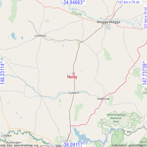
Henty GPS coordinates[2]
35° 31' 15.384" South, 147° 2' 3.336" East
| Map corner | latitude | longitude |
|---|---|---|
| Upper-left | -34.94663°, | 146.33114° |
| Center: | -35.52094°, | 147.03426° |
| Lower-right: | -36.09117°, | 147.73739° |
| Map W x H: | 127.3×127.3 km | = 79.1×79.1mi |
| max Lat: | -10.58257° ⇑77.2% North |
| Henty: | -35.52094° |
| min Lat: | ⇓22.8% South -43.31423° |
| min Long | Henty | max Long |
| 113.53327° | 147.03426° | 153.61246° |
| W 47.1%⇐ | ⇒52.9% E |
Elevation
Elevation of Henty is 239 m = 784 ft, and this is 117 m = 384 ft above average elevation for this country.
| Max E: |
1715 m = 5627 ft | 15.5% |
| Henty | 239 m 784 ft | |
| Avg. | 122 m = 400 ft | |
Min E: |
-2 m = -7 ft | 84.5% |
See also: Australia elevation on elevation.city.
Geographical zone
Henty is located in South temperate zone (between Tropic of Capricorn and the Antarctic Circle). Distance of this Southern Tropic circle is 1343.6 km =834.9 mi to North.| Distance of | km | miles | from Henty |
|---|---|---|---|
| Equator | 3949.6 | 2454.2 | to North |
| Tropic Capricorn | 1343.6 | 834.9 | to North |
| Antarctic Circle | 3451.6 | 2144.7 | to South |
| South Pole | 6057.5 | 3764 | to South |


Nearby cities:
15 places around Henty: (largest is in red/bold)
• Bourkelands
49.5 km =30.8 mi,  34°
34°
• Culcairn
16.2 km =10.1 mi,  178°
178°
• Gerogery
35.1 km =21.8 mi,  186°
186°
• Glenfield Park
50.5 km =31.4 mi, 32°
• Holbrook
33.8 km =21 mi,  131°
131°
• Jindera
50 km =31.1 mi,  195°
195°
• Kapooka
46.4 km =28.8 mi, 29°
• Lloyd
49.5 km =30.8 mi, 33°
• Lockhart
43.8 km =27.2 mi,  319°
319°
• Springvale
47.7 km =29.6 mi, 34°
• Table Top
49.7 km =30.9 mi, 183°
• Tatton
49.8 km =30.9 mi,  36°
36°
• The Rock
28.5 km =17.7 mi,  14°
14°
• Uranquinty
41.2 km =25.6 mi, 27°
• Walla Walla
29.4 km =18.3 mi, 204°
Sources, notices
• [Note1] Compared only with cities in Australia existing in our database
• [Src1] Map data: © OpenStreetMap contributors (CC-BY-SA)
• [Src2] Other city data from geonames.org with taken over terms of usage.
• [Src3] Geographical zone / Annual Mean Temperature by Robert A. Rohde @ Wikipedia
