Flowerdale geodata
Flowerdale (Victoria) is a populated place; located in Australia in Australia/Melbourne (GMT+11) time zone. With population of 661 people, there are 4404 cities with bigger population in this country. Compared to other cities in Australia, 82.2% of cities are located further ↑North; 61.2% of cities are located further →East and 89.4% of cities have lower elevation than Flowerdale. Note1


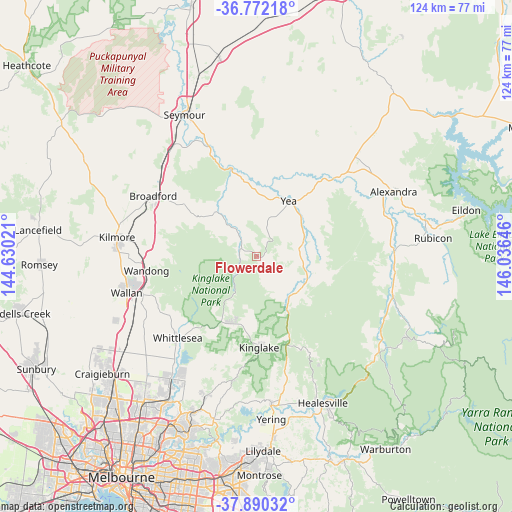
Flowerdale GPS coordinates[2]
37° 19' 59.988" South, 145° 19' 59.988" East
| Map corner | latitude | longitude |
|---|---|---|
| Upper-left | -36.77218°, | 144.63021° |
| Center: | -37.33333°, | 145.33333° |
| Lower-right: | -37.89032°, | 146.03646° |
| Map W x H: | 124.3×124.3 km | = 77.2×77.2mi |
| max Lat: | -10.58257° ⇑82.2% North |
| Flowerdale: | -37.33333° |
| min Lat: | ⇓17.8% South -43.31423° |
| min Long | Flowerdale | max Long |
| 113.53327° | 145.33333° | 153.61246° |
| W 38.8%⇐ | ⇒61.2% E |
Elevation
Elevation of Flowerdale is 356 m = 1168 ft, and this is 234 m = 768 ft above average elevation for this country.
| Max E: |
1715 m = 5627 ft | 10.6% |
| Flowerdale | 356 m 1168 ft | |
| Avg. | 122 m = 400 ft | |
Min E: |
-2 m = -7 ft | 89.4% |
See also: Australia elevation on elevation.city.
Geographical zone
Flowerdale is located in South temperate zone (between Tropic of Capricorn and the Antarctic Circle). Distance of this Southern Tropic circle is 1545.2 km =960.1 mi to North.| Distance of | km | miles | from Flowerdale |
|---|---|---|---|
| Equator | 4151.1 | 2579.4 | to North |
| Tropic Capricorn | 1545.2 | 960.1 | to North |
| Antarctic Circle | 3250.1 | 2019.5 | to South |
| South Pole | 5856 | 3638.7 | to South |


Nearby cities:
15 places around Flowerdale: (largest is in red/bold)
• Beveridge
35.1 km =21.8 mi,  241°
241°
• Broadford
29.1 km =18.1 mi,  299°
299°
• Chum Creek
33.1 km =20.6 mi,  155°
155°
• Cottles Bridge
32 km =19.9 mi,  197°
197°
• Doreen
33.8 km =21 mi,  208°
208°
• Eden Park
27.7 km =17.2 mi,  232°
232°
• Kilmore
33.9 km =21.1 mi,  277°
277°
• Kinglake
22.2 km =13.8 mi,  178°
178°
• Kinglake West
17.3 km =10.7 mi, 210°
• Saint Andrews
30.3 km =18.8 mi,  190°
190°
• Tallarook
33.7 km =20.9 mi,  322°
322°
• Wallan
32.7 km =20.3 mi,  253°
253°
• Wandong
27 km =16.8 mi,  260°
260°
• Whittlesea
27.4 km =17 mi,  223°
223°
• Yea
16 km =9.9 mi,  31°
31°
Sources, notices
• [Note1] Compared only with cities in Australia existing in our database
• [Src1] Map data: © OpenStreetMap contributors (CC-BY-SA)
• [Src2] Other city data from geonames.org with taken over terms of usage.
• [Src3] Geographical zone / Annual Mean Temperature by Robert A. Rohde @ Wikipedia
