Kempsey geodata
Kempsey (New South Wales) is a seat of a second-order administrative division; located in Australia in Australia/Sydney (GMT+11) time zone. With population of 9,522 people, there are 647 cities with bigger population in this country. Compared to other cities in Australia, 70.5% of cities are located further ↓South; 87.4% of cities are located further ←West and 96.8% of cities have higher elevation than Kempsey. Note1


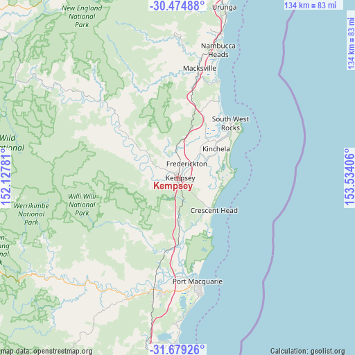
Kempsey GPS coordinates[2]
31° 4' 44.328" South, 152° 49' 51.348" East
| Map corner | latitude | longitude |
|---|---|---|
| Upper-left | -30.47488°, | 152.12781° |
| Center: | -31.07898°, | 152.83093° |
| Lower-right: | -31.67926°, | 153.53406° |
| Map W x H: | 133.9×133.9 km | = 83.2×83.2mi |
| max Lat: | -10.58257° ⇑29.5% North |
| Kempsey: | -31.07898° |
| min Lat: | ⇓70.5% South -43.31423° |
| min Long | Kempsey | max Long |
| 113.53327° | 152.83093° | 153.61246° |
| W 87.4%⇐ | ⇒12.6% E |
Elevation
Elevation of Kempsey is 5 m = 16 ft, and this is 117 m = 384 ft below average elevation for this country.
| Max E: |
1715 m = 5627 ft | 96.8% |
| Avg. | 122 m = 400 ft | |
| Kempsey | 5 m = 16 ft | |
Min E: |
-2 m = -7 ft | 3.2% |
See also: Australia elevation on elevation.city.
Geographical zone
Kempsey is located in South temperate zone (between Tropic of Capricorn and the Antarctic Circle). Distance of this Southern Tropic circle is 849.7 km =528 mi to North.| Distance of | km | miles | from Kempsey |
|---|---|---|---|
| Equator | 3455.7 | 2147.3 | to North |
| Tropic Capricorn | 849.7 | 528 | to North |
| Antarctic Circle | 3945.5 | 2451.6 | to South |
| South Pole | 6551.4 | 4070.8 | to South |


Nearby cities:
15 places around Kempsey: (largest is in red/bold)
• Aldavilla
6 km =3.7 mi,  267°
267°
• Collombatti
10.9 km =6.8 mi,  357°
357°
• Crescent Head
18.2 km =11.3 mi,  132°
132°
• Dondingalong
9.7 km =6 mi,  231°
231°
• East Kempsey
2.1 km =1.3 mi,  100°
100°
• Frederickton
6.3 km =3.9 mi,  42°
42°
• Green Hill
3.6 km =2.2 mi,  308°
308°
• Kempsey city centre
0.5 km =0.3 mi,  70°
70°
• Kundabung
14.5 km =9 mi,  179°
179°
• Smithtown
13.1 km =8.1 mi,  56°
56°
• South Kempsey
4.9 km =3 mi, 178°
• South West Rocks
29.4 km =18.3 mi, 42°
• Telegraph Point
27.5 km =17.1 mi,  186°
186°
• West Kempsey
2.4 km =1.5 mi,  353°
353°
• Yarravel
7.7 km =4.8 mi,  301°
301°
Sources, notices
• [Note1] Compared only with cities in Australia existing in our database
• [Src1] Map data: © OpenStreetMap contributors (CC-BY-SA)
• [Src2] Other city data from geonames.org with taken over terms of usage.
• [Src3] Geographical zone / Annual Mean Temperature by Robert A. Rohde @ Wikipedia
