Dondingalong geodata
Dondingalong (New South Wales) is a section of populated place; located in Australia in Australia/Sydney (GMT+11) time zone. With population of 652 people, there are 4434 cities with bigger population in this country. Compared to other cities in Australia, 70.3% of cities are located further ↓South; 86.3% of cities are located further ←West and 69.5% of cities have lower elevation than Dondingalong. Note1


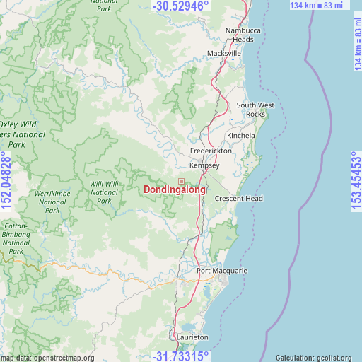
Dondingalong GPS coordinates[2]
31° 7' 59.556" South, 152° 45' 5.04" East
| Map corner | latitude | longitude |
|---|---|---|
| Upper-left | -30.52946°, | 152.04828° |
| Center: | -31.13321°, | 152.7514° |
| Lower-right: | -31.73315°, | 153.45453° |
| Map W x H: | 133.8×133.8 km | = 83.1×83.1mi |
| max Lat: | -10.58257° ⇑29.7% North |
| Dondingalong: | -31.13321° |
| min Lat: | ⇓70.3% South -43.31423° |
| min Long | Dondingalong | max Long |
| 113.53327° | 152.7514° | 153.61246° |
| W 86.3%⇐ | ⇒13.7% E |
Elevation
Elevation of Dondingalong is 100 m = 328 ft, and this is 22 m = 72 ft below average elevation for this country.
| Max E: |
1715 m = 5627 ft | 30.5% |
| Avg. | 122 m = 400 ft | |
| Dondingalong | 100 m = 328 ft | |
Min E: |
-2 m = -7 ft | 69.5% |
See also: Australia elevation on elevation.city.
Geographical zone
Dondingalong is located in South temperate zone (between Tropic of Capricorn and the Antarctic Circle). Distance of this Southern Tropic circle is 855.8 km =531.8 mi to North.| Distance of | km | miles | from Dondingalong |
|---|---|---|---|
| Equator | 3461.7 | 2151 | to North |
| Tropic Capricorn | 855.8 | 531.8 | to North |
| Antarctic Circle | 3939.5 | 2447.9 | to South |
| South Pole | 6545.4 | 4067.1 | to South |


Nearby cities:
15 places around Dondingalong: (largest is in red/bold)
• Aldavilla
5.9 km =3.7 mi,  15°
15°
• Collombatti
18.3 km =11.4 mi, 22°
• Crescent Head
22 km =13.7 mi,  106°
106°
• East Kempsey
11.2 km =7 mi,  59°
59°
• Frederickton
15.9 km =9.9 mi,  47°
47°
• Green Hill
9.5 km =5.9 mi,  30°
30°
• Kempsey
9.7 km =6 mi, 51°
• Kempsey city centre
10.1 km =6.3 mi, 52°
• Kundabung
11.4 km =7.1 mi,  138°
138°
• Sancrox
33.5 km =20.8 mi,  171°
171°
• Smithtown
22.7 km =14.1 mi, 54°
• South Kempsey
7.8 km =4.8 mi,  81°
81°
• Telegraph Point
21.8 km =13.5 mi, 167°
• West Kempsey
11.1 km =6.9 mi,  40°
40°
• Yarravel
10.1 km =6.3 mi,  5°
5°
Sources, notices
• [Note1] Compared only with cities in Australia existing in our database
• [Src1] Map data: © OpenStreetMap contributors (CC-BY-SA)
• [Src2] Other city data from geonames.org with taken over terms of usage.
• [Src3] Geographical zone / Annual Mean Temperature by Robert A. Rohde @ Wikipedia
