Jeeralang Junction geodata
Jeeralang Junction (Victoria) is a populated place; located in Australia in Australia/Melbourne (GMT+11) time zone. With population of 541 people, there are 4743 cities with bigger population in this country. Compared to other cities in Australia, 95.1% of cities are located further ↑North; 55.6% of cities are located further →East and 77.4% of cities have lower elevation than Jeeralang Junction. Note1


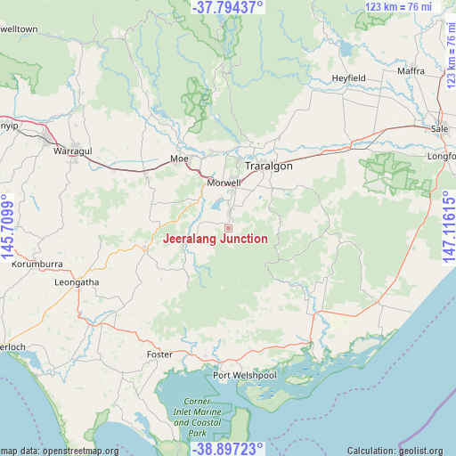
Jeeralang Junction GPS coordinates[2]
38° 20' 52.44" South, 146° 24' 46.872" East
| Map corner | latitude | longitude |
|---|---|---|
| Upper-left | -37.79437°, | 145.7099° |
| Center: | -38.3479°, | 146.41302° |
| Lower-right: | -38.89723°, | 147.11615° |
| Map W x H: | 122.6×122.6 km | = 76.2×76.2mi |
| max Lat: | -10.58257° ⇑95.1% North |
| Jeeralang Junction: | -38.3479° |
| min Lat: | ⇓4.9% South -43.31423° |
| min Long | Jeeralang Junct | max Long |
| 113.53327° | 146.41302° | 153.61246° |
| W 44.4%⇐ | ⇒55.6% E |
Elevation
Elevation of Jeeralang Junction is 150 m = 492 ft, and this is 28 m = 92 ft above average elevation for this country.
| Max E: |
1715 m = 5627 ft | 22.6% |
| Jeeralang Junction | 150 m 492 ft | |
| Avg. | 122 m = 400 ft | |
Min E: |
-2 m = -7 ft | 77.4% |
See also: Australia elevation on elevation.city.
Geographical zone
Jeeralang Junction is located in South temperate zone (between Tropic of Capricorn and the Antarctic Circle). Distance of this Southern Tropic circle is 1658 km =1030.2 mi to North.| Distance of | km | miles | from Jeeralang Junction |
|---|---|---|---|
| Equator | 4263.9 | 2649.5 | to North |
| Tropic Capricorn | 1658 | 1030.2 | to North |
| Antarctic Circle | 3137.3 | 1949.4 | to South |
| South Pole | 5743.2 | 3568.7 | to South |


Nearby cities:
15 places around Jeeralang Junction: (largest is in red/bold)
• Boolarra
12.5 km =7.8 mi,  253°
253°
• Churchill
4.5 km =2.8 mi,  0°
0°
• Hazelwood North
10.8 km =6.7 mi,  34°
34°
• Mirboo North
22.7 km =14.1 mi, 254°
• Moe
23.1 km =14.4 mi,  324°
324°
• Moe South
20.6 km =12.8 mi, 316°
• Morwell
12.7 km =7.9 mi,  352°
352°
• Newborough
22.2 km =13.8 mi,  331°
331°
• Trafalgar
27.4 km =17 mi,  304°
304°
• Traralgon
20.3 km =12.6 mi, 33°
• Traralgon South
13.3 km =8.3 mi,  60°
60°
• Tyers
22.9 km =14.2 mi,  14°
14°
• Yallourn North
21.3 km =13.2 mi, 348°
• Yinnar
7.8 km =4.8 mi,  291°
291°
• Yinnar South
4.7 km =2.9 mi,  213°
213°
Sources, notices
• [Note1] Compared only with cities in Australia existing in our database
• [Src1] Map data: © OpenStreetMap contributors (CC-BY-SA)
• [Src2] Other city data from geonames.org with taken over terms of usage.
• [Src3] Geographical zone / Annual Mean Temperature by Robert A. Rohde @ Wikipedia
