Newborough geodata
Newborough (Victoria) is a section of populated place; located in Australia in Australia/Melbourne (GMT+11) time zone. With population of 6,601 people, there are 1051 cities with bigger population in this country. Compared to other cities in Australia, 93.8% of cities are located further ↑North; 56% of cities are located further →East and 64% of cities have lower elevation than Newborough. Note1


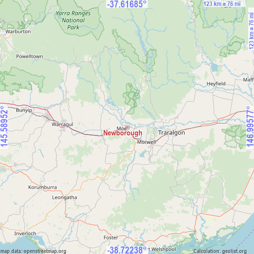
Newborough GPS coordinates[2]
38° 10' 18.156" South, 146° 17' 33.504" East
| Map corner | latitude | longitude |
|---|---|---|
| Upper-left | -37.61685°, | 145.58952° |
| Center: | -38.17171°, | 146.29264° |
| Lower-right: | -38.72238°, | 146.99577° |
| Map W x H: | 122.9×122.9 km | = 76.4×76.4mi |
| max Lat: | -10.58257° ⇑93.8% North |
| Newborough: | -38.17171° |
| min Lat: | ⇓6.2% South -43.31423° |
| min Long | Newborough | max Long |
| 113.53327° | 146.29264° | 153.61246° |
| W 44%⇐ | ⇒56% E |
Elevation
Elevation of Newborough is 76 m = 249 ft, and this is 46 m = 151 ft below average elevation for this country.
| Max E: |
1715 m = 5627 ft | 36% |
| Avg. | 122 m = 400 ft | |
| Newborough | 76 m = 249 ft | |
Min E: |
-2 m = -7 ft | 64% |
See also: Australia elevation on elevation.city.
Geographical zone
Newborough is located in South temperate zone (between Tropic of Capricorn and the Antarctic Circle). Distance of this Southern Tropic circle is 1638.4 km =1018.1 mi to North.| Distance of | km | miles | from Newborough |
|---|---|---|---|
| Equator | 4244.3 | 2637.3 | to North |
| Tropic Capricorn | 1638.4 | 1018.1 | to North |
| Antarctic Circle | 3156.9 | 1961.6 | to South |
| South Pole | 5762.8 | 3580.8 | to South |


Nearby cities:
15 places around Newborough: (largest is in red/bold)
• Boolarra
23.1 km =14.4 mi,  183°
183°
• Churchill
18.5 km =11.5 mi,  145°
145°
• Hazelwood North
19.7 km =12.2 mi,  122°
122°
• Jeeralang Junction
22.2 km =13.8 mi, 151°
• Moe
2.9 km =1.8 mi,  255°
255°
• Moe South
5.8 km =3.6 mi,  217°
217°
• Morwell
11.4 km =7.1 mi,  128°
128°
• Tanjil South
7.2 km =4.5 mi,  328°
328°
• Trafalgar
12.9 km =8 mi,  251°
251°
• Traralgon
21.9 km =13.6 mi,  96°
96°
• Tyers
16.6 km =10.3 mi,  81°
81°
• Willow Grove
12.7 km =7.9 mi,  320°
320°
• Yallourn North
6.4 km =4 mi, 78°
• Yarragon
20.6 km =12.8 mi, 259°
• Yinnar
17.1 km =10.6 mi,  169°
169°
Sources, notices
• [Note1] Compared only with cities in Australia existing in our database
• [Src1] Map data: © OpenStreetMap contributors (CC-BY-SA)
• [Src2] Other city data from geonames.org with taken over terms of usage.
• [Src3] Geographical zone / Annual Mean Temperature by Robert A. Rohde @ Wikipedia
