Tyers geodata
Tyers (Victoria) is a populated place; located in Australia in Australia/Melbourne (GMT+11) time zone. With population of 784 people, there are 4175 cities with bigger population in this country. Compared to other cities in Australia, 93.4% of cities are located further ↑North; 55.4% of cities are located further →East and 61.4% of cities have lower elevation than Tyers. Note1


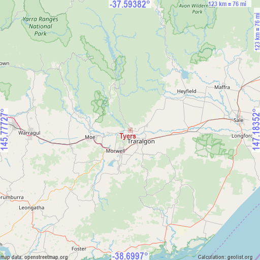
Tyers GPS coordinates[2]
38° 8' 55.896" South, 146° 28' 49.404" East
| Map corner | latitude | longitude |
|---|---|---|
| Upper-left | -37.59382°, | 145.77727° |
| Center: | -38.14886°, | 146.48039° |
| Lower-right: | -38.6997°, | 147.18352° |
| Map W x H: | 123×123 km | = 76.4×76.4mi |
| max Lat: | -10.58257° ⇑93.4% North |
| Tyers: | -38.14886° |
| min Lat: | ⇓6.6% South -43.31423° |
| min Long | Tyers | max Long |
| 113.53327° | 146.48039° | 153.61246° |
| W 44.6%⇐ | ⇒55.4% E |
Elevation
Elevation of Tyers is 68 m = 223 ft, and this is 54 m = 177 ft below average elevation for this country.
| Max E: |
1715 m = 5627 ft | 38.6% |
| Avg. | 122 m = 400 ft | |
| Tyers | 68 m = 223 ft | |
Min E: |
-2 m = -7 ft | 61.4% |
See also: Australia elevation on elevation.city.
Geographical zone
Tyers is located in South temperate zone (between Tropic of Capricorn and the Antarctic Circle). Distance of this Southern Tropic circle is 1635.8 km =1016.4 mi to North.| Distance of | km | miles | from Tyers |
|---|---|---|---|
| Equator | 4241.8 | 2635.7 | to North |
| Tropic Capricorn | 1635.8 | 1016.4 | to North |
| Antarctic Circle | 3159.4 | 1963.2 | to South |
| South Pole | 5765.3 | 3582.4 | to South |


Nearby cities:
15 places around Tyers: (largest is in red/bold)
• Churchill
18.6 km =11.6 mi,  198°
198°
• Glengarry
8.4 km =5.2 mi,  64°
64°
• Hazelwood North
13.2 km =8.2 mi,  179°
179°
• Jeeralang Junction
22.9 km =14.2 mi,  194°
194°
• Moe
19.5 km =12.1 mi,  260°
260°
• Moe South
21.2 km =13.2 mi,  250°
250°
• Morwell
12.1 km =7.5 mi,  218°
218°
• Newborough
16.6 km =10.3 mi, 261°
• Tanjil South
20.5 km =12.7 mi,  280°
280°
• Toongabbie
16.2 km =10.1 mi,  47°
47°
• Traralgon
7.4 km =4.6 mi,  134°
134°
• Traralgon South
16.7 km =10.4 mi,  159°
159°
• Willow Grove
25.6 km =15.9 mi,  286°
286°
• Yallourn North
10.2 km =6.3 mi, 262°
• Yinnar
23.4 km =14.5 mi,  214°
214°
Sources, notices
• [Note1] Compared only with cities in Australia existing in our database
• [Src1] Map data: © OpenStreetMap contributors (CC-BY-SA)
• [Src2] Other city data from geonames.org with taken over terms of usage.
• [Src3] Geographical zone / Annual Mean Temperature by Robert A. Rohde @ Wikipedia
