Traralgon geodata
Traralgon (Victoria) is a populated place; located in Australia in Australia/Melbourne (GMT+11) time zone. With population of 24,605 people, there are 105 cities with bigger population in this country. Compared to other cities in Australia, 94% of cities are located further ↑North; 55.3% of cities are located further →East and 50.2% of cities have lower elevation than Traralgon. Note1


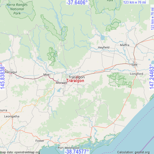
Traralgon GPS coordinates[2]
38° 11' 43.008" South, 146° 32' 29.4" East
| Map corner | latitude | longitude |
|---|---|---|
| Upper-left | -37.6406°, | 145.83838° |
| Center: | -38.19528°, | 146.5415° |
| Lower-right: | -38.74577°, | 147.24463° |
| Map W x H: | 122.9×122.9 km | = 76.4×76.4mi |
| max Lat: | -10.58257° ⇑94% North |
| Traralgon: | -38.19528° |
| min Lat: | ⇓6% South -43.31423° |
| min Long | Traralgon | max Long |
| 113.53327° | 146.5415° | 153.61246° |
| W 44.7%⇐ | ⇒55.3% E |
Elevation
Elevation of Traralgon is 46 m = 151 ft, and this is 76 m = 249 ft below average elevation for this country.
| Max E: |
1715 m = 5627 ft | 49.8% |
| Avg. | 122 m = 400 ft | |
| Traralgon | 46 m = 151 ft | |
Min E: |
-2 m = -7 ft | 50.2% |
See also: Australia elevation on elevation.city.
Geographical zone
Traralgon is located in South temperate zone (between Tropic of Capricorn and the Antarctic Circle). Distance of this Southern Tropic circle is 1641 km =1019.7 mi to North.| Distance of | km | miles | from Traralgon |
|---|---|---|---|
| Equator | 4246.9 | 2638.9 | to North |
| Tropic Capricorn | 1641 | 1019.7 | to North |
| Antarctic Circle | 3154.3 | 1960 | to South |
| South Pole | 5760.1 | 3579.2 | to South |


Nearby cities:
15 places around Traralgon: (largest is in red/bold)
• Churchill
16.8 km =10.4 mi,  221°
221°
• Glengarry
9 km =5.6 mi,  14°
14°
• Hazelwood North
9.5 km =5.9 mi,  212°
212°
• Jeeralang Junction
20.3 km =12.6 mi, 213°
• Moe
24.6 km =15.3 mi,  274°
274°
• Moe South
25.3 km =15.7 mi, 265°
• Morwell
13.5 km =8.4 mi,  251°
251°
• Newborough
21.9 km =13.6 mi,  276°
276°
• Rosedale
22.1 km =13.7 mi,  78°
78°
• Toongabbie
17.4 km =10.8 mi,  22°
22°
• Traralgon South
10.5 km =6.5 mi,  177°
177°
• Tyers
7.4 km =4.6 mi,  314°
314°
• Yallourn North
15.9 km =9.9 mi, 284°
• Yinnar
23.3 km =14.5 mi,  232°
232°
• Yinnar South
25.1 km =15.6 mi, 213°
Sources, notices
• [Note1] Compared only with cities in Australia existing in our database
• [Src1] Map data: © OpenStreetMap contributors (CC-BY-SA)
• [Src2] Other city data from geonames.org with taken over terms of usage.
• [Src3] Geographical zone / Annual Mean Temperature by Robert A. Rohde @ Wikipedia
