Greta geodata
Greta (New South Wales) is a section of populated place; located in Australia in Australia/Sydney (GMT+11) time zone. With population of 2,817 people, there are 2370 cities with bigger population in this country. Compared to other cities in Australia, 60.8% of cities are located further ↓South; 76.8% of cities are located further ←West and 55% of cities have lower elevation than Greta. Note1


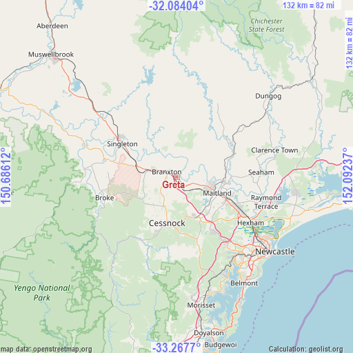
Greta GPS coordinates[2]
32° 40' 40.188" South, 151° 23' 21.264" East
| Map corner | latitude | longitude |
|---|---|---|
| Upper-left | -32.08404°, | 150.68612° |
| Center: | -32.67783°, | 151.38924° |
| Lower-right: | -33.2677°, | 152.09237° |
| Map W x H: | 131.6×131.6 km | = 81.8×81.8mi |
| max Lat: | -10.58257° ⇑39.2% North |
| Greta: | -32.67783° |
| min Lat: | ⇓60.8% South -43.31423° |
| min Long | Greta | max Long |
| 113.53327° | 151.38924° | 153.61246° |
| W 76.8%⇐ | ⇒23.2% E |
Elevation
Elevation of Greta is 53 m = 174 ft, and this is 69 m = 226 ft below average elevation for this country.
| Max E: |
1715 m = 5627 ft | 45% |
| Avg. | 122 m = 400 ft | |
| Greta | 53 m = 174 ft | |
Min E: |
-2 m = -7 ft | 55% |
See also: Australia elevation on elevation.city.
Geographical zone
Greta is located in South temperate zone (between Tropic of Capricorn and the Antarctic Circle). Distance of this Southern Tropic circle is 1027.5 km =638.5 mi to North.| Distance of | km | miles | from Greta |
|---|---|---|---|
| Equator | 3633.4 | 2257.7 | to North |
| Tropic Capricorn | 1027.5 | 638.5 | to North |
| Antarctic Circle | 3767.7 | 2341.1 | to South |
| South Pole | 6373.6 | 3960.4 | to South |


Nearby cities:
15 places around Greta: (largest is in red/bold)
• Aberglasslyn
13.7 km =8.5 mi,  100°
100°
• Abermain
14.8 km =9.2 mi,  166°
166°
• Branxton
4.3 km =2.7 mi,  304°
304°
• East Branxton
3.5 km =2.2 mi,  320°
320°
• Gillieston Heights
16 km =9.9 mi,  125°
125°
• Lochinvar
6.6 km =4.1 mi,  110°
110°
• Lovedale
10.6 km =6.6 mi,  192°
192°
• Maitland
16.9 km =10.5 mi, 111°
• Maitland city centre
16.5 km =10.3 mi, 111°
• North Rothbury
4.6 km =2.9 mi,  247°
247°
• Nulkaba
15.2 km =9.4 mi, 194°
• Pokolbin
16.8 km =10.4 mi,  216°
216°
• Rutherford
14.2 km =8.8 mi, 107°
• Telarah
14.7 km =9.1 mi, 112°
• Windella
9 km =5.6 mi, 108°
Sources, notices
• [Note1] Compared only with cities in Australia existing in our database
• [Src1] Map data: © OpenStreetMap contributors (CC-BY-SA)
• [Src2] Other city data from geonames.org with taken over terms of usage.
• [Src3] Geographical zone / Annual Mean Temperature by Robert A. Rohde @ Wikipedia
