North Rothbury geodata
North Rothbury (New South Wales) is a populated place; located in Australia in Australia/Sydney (GMT+11) time zone. With population of 898 people, there are 3973 cities with bigger population in this country. Compared to other cities in Australia, 60.7% of cities are located further ↓South; 76.3% of cities are located further ←West and 55.4% of cities have lower elevation than North Rothbury. Note1


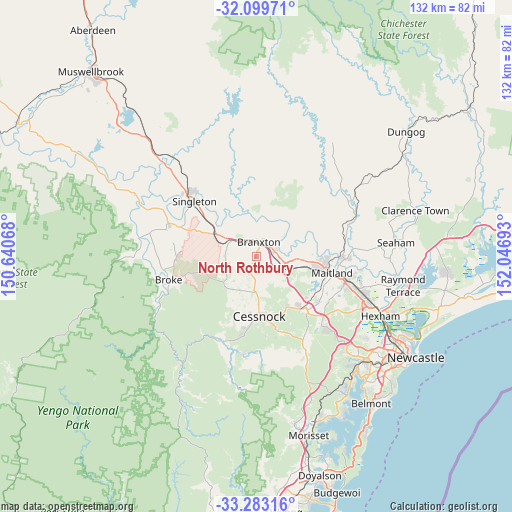
North Rothbury GPS coordinates[2]
32° 41' 36.24" South, 151° 20' 37.68" East
| Map corner | latitude | longitude |
|---|---|---|
| Upper-left | -32.09971°, | 150.64068° |
| Center: | -32.6934°, | 151.3438° |
| Lower-right: | -33.28316°, | 152.04693° |
| Map W x H: | 131.6×131.6 km | = 81.8×81.8mi |
| max Lat: | -10.58257° ⇑39.3% North |
| North Rothbury: | -32.6934° |
| min Lat: | ⇓60.7% South -43.31423° |
| min Long | North Rothbury | max Long |
| 113.53327° | 151.3438° | 153.61246° |
| W 76.3%⇐ | ⇒23.7% E |
Elevation
Elevation of North Rothbury is 54 m = 177 ft, and this is 68 m = 223 ft below average elevation for this country.
| Max E: |
1715 m = 5627 ft | 44.6% |
| Avg. | 122 m = 400 ft | |
| North Rothbury | 54 m = 177 ft | |
Min E: |
-2 m = -7 ft | 55.4% |
See also: Australia elevation on elevation.city.
Geographical zone
North Rothbury is located in South temperate zone (between Tropic of Capricorn and the Antarctic Circle). Distance of this Southern Tropic circle is 1029.2 km =639.5 mi to North.| Distance of | km | miles | from North Rothbury |
|---|---|---|---|
| Equator | 3635.2 | 2258.8 | to North |
| Tropic Capricorn | 1029.2 | 639.5 | to North |
| Antarctic Circle | 3766 | 2340.1 | to South |
| South Pole | 6371.9 | 3959.3 | to South |


Nearby cities:
15 places around North Rothbury: (largest is in red/bold)
• Aberdare
16.8 km =10.4 mi,  167°
167°
• Aberglasslyn
17.7 km =11 mi,  92°
92°
• Abermain
14.9 km =9.3 mi,  148°
148°
• Bellbird Heights
17.5 km =10.9 mi,  184°
184°
• Branxton
4.3 km =2.7 mi,  9°
9°
• Cessnock
15.5 km =9.6 mi, 175°
• East Branxton
4.9 km =3 mi,  24°
24°
• Greta
4.6 km =2.9 mi,  67°
67°
• Lochinvar
10.4 km =6.5 mi, 93°
• Lovedale
8.8 km =5.5 mi, 167°
• Nulkaba
13 km =8.1 mi, 178°
• Pokolbin
13.1 km =8.1 mi,  205°
205°
• Rutherford
17.9 km =11.1 mi,  98°
98°
• Telarah
18.3 km =11.4 mi, 102°
• Windella
12.8 km =8 mi, 94°
Sources, notices
• [Note1] Compared only with cities in Australia existing in our database
• [Src1] Map data: © OpenStreetMap contributors (CC-BY-SA)
• [Src2] Other city data from geonames.org with taken over terms of usage.
• [Src3] Geographical zone / Annual Mean Temperature by Robert A. Rohde @ Wikipedia
