East Branxton geodata
East Branxton (New South Wales) is a section of populated place; located in Australia in Australia/Sydney (GMT+11) time zone. With population of 1,806 people, there are 3042 cities with bigger population in this country. Compared to other cities in Australia, 60.9% of cities are located further ↓South; 76.6% of cities are located further ←West and 51.1% of cities have higher elevation than East Branxton. Note1


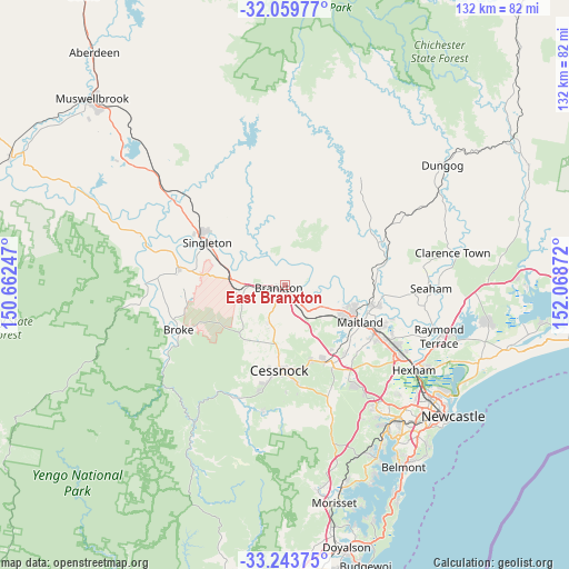
East Branxton GPS coordinates[2]
32° 39' 13.392" South, 151° 21' 56.124" East
| Map corner | latitude | longitude |
|---|---|---|
| Upper-left | -32.05977°, | 150.66247° |
| Center: | -32.65372°, | 151.36559° |
| Lower-right: | -33.24375°, | 152.06872° |
| Map W x H: | 131.6×131.6 km | = 81.8×81.8mi |
| max Lat: | -10.58257° ⇑39.1% North |
| East Branxton: | -32.65372° |
| min Lat: | ⇓60.9% South -43.31423° |
| min Long | East Branxton | max Long |
| 113.53327° | 151.36559° | 153.61246° |
| W 76.6%⇐ | ⇒23.4% E |
Elevation
Elevation of East Branxton is 44 m = 144 ft, and this is 78 m = 256 ft below average elevation for this country.
| Max E: |
1715 m = 5627 ft | 51.1% |
| Avg. | 122 m = 400 ft | |
| East Branxton | 44 m = 144 ft | |
Min E: |
-2 m = -7 ft | 48.9% |
See also: Australia elevation on elevation.city.
Geographical zone
East Branxton is located in South temperate zone (between Tropic of Capricorn and the Antarctic Circle). Distance of this Southern Tropic circle is 1024.8 km =636.8 mi to North.| Distance of | km | miles | from East Branxton |
|---|---|---|---|
| Equator | 3630.8 | 2256.1 | to North |
| Tropic Capricorn | 1024.8 | 636.8 | to North |
| Antarctic Circle | 3770.4 | 2342.8 | to South |
| South Pole | 6376.3 | 3962 | to South |


Nearby cities:
15 places around East Branxton: (largest is in red/bold)
• Aberglasslyn
16.5 km =10.3 mi,  108°
108°
• Abermain
18 km =11.2 mi,  161°
161°
• Branxton
1.4 km =0.9 mi,  261°
261°
• Cessnock
19.9 km =12.4 mi,  182°
182°
• Gillieston Heights
19.4 km =12.1 mi,  128°
128°
• Greta
3.5 km =2.2 mi,  140°
140°
• Lochinvar
9.8 km =6.1 mi,  120°
120°
• Lovedale
13 km =8.1 mi, 180°
• Maitland city centre
19.6 km =12.2 mi, 116°
• North Rothbury
4.9 km =3 mi,  204°
204°
• Nulkaba
17.5 km =10.9 mi,  185°
185°
• Pokolbin
18 km =11.2 mi,  205°
205°
• Rutherford
17.2 km =10.7 mi, 114°
• Telarah
17.9 km =11.1 mi, 117°
• Windella
12.1 km =7.5 mi, 117°
Sources, notices
• [Note1] Compared only with cities in Australia existing in our database
• [Src1] Map data: © OpenStreetMap contributors (CC-BY-SA)
• [Src2] Other city data from geonames.org with taken over terms of usage.
• [Src3] Geographical zone / Annual Mean Temperature by Robert A. Rohde @ Wikipedia
