Branxton geodata
Branxton (New South Wales) is a section of populated place; located in Australia in Australia/Sydney (GMT+11) time zone. With population of 1,957 people, there are 2938 cities with bigger population in this country. Compared to other cities in Australia, 60.8% of cities are located further ↓South; 76.4% of cities are located further ←West and 57.6% of cities have higher elevation than Branxton. Note1


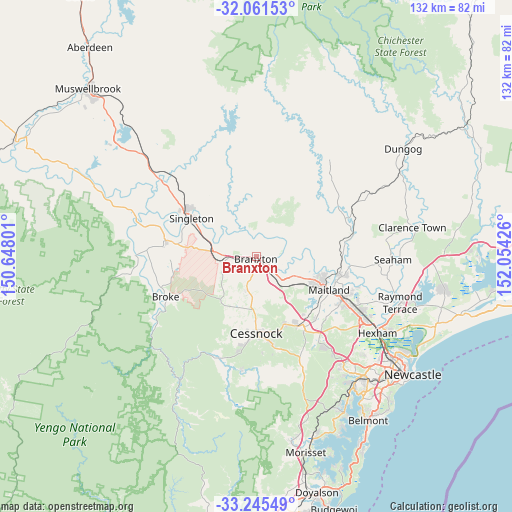
Branxton GPS coordinates[2]
32° 39' 19.692" South, 151° 21' 4.068" East
| Map corner | latitude | longitude |
|---|---|---|
| Upper-left | -32.06153°, | 150.64801° |
| Center: | -32.65547°, | 151.35113° |
| Lower-right: | -33.24549°, | 152.05426° |
| Map W x H: | 131.6×131.6 km | = 81.8×81.8mi |
| max Lat: | -10.58257° ⇑39.2% North |
| Branxton: | -32.65547° |
| min Lat: | ⇓60.8% South -43.31423° |
| min Long | Branxton | max Long |
| 113.53327° | 151.35113° | 153.61246° |
| W 76.4%⇐ | ⇒23.6% E |
Elevation
Elevation of Branxton is 35 m = 115 ft, and this is 87 m = 285 ft below average elevation for this country.
| Max E: |
1715 m = 5627 ft | 57.6% |
| Avg. | 122 m = 400 ft | |
| Branxton | 35 m = 115 ft | |
Min E: |
-2 m = -7 ft | 42.4% |
See also: Australia elevation on elevation.city.
Geographical zone
Branxton is located in South temperate zone (between Tropic of Capricorn and the Antarctic Circle). Distance of this Southern Tropic circle is 1025 km =636.9 mi to North.| Distance of | km | miles | from Branxton |
|---|---|---|---|
| Equator | 3630.9 | 2256.1 | to North |
| Tropic Capricorn | 1025 | 636.9 | to North |
| Antarctic Circle | 3770.2 | 2342.7 | to South |
| South Pole | 6376.1 | 3961.9 | to South |


Nearby cities:
15 places around Branxton: (largest is in red/bold)
• Aberglasslyn
17.8 km =11.1 mi,  106°
106°
• Abermain
18.3 km =11.4 mi,  157°
157°
• Cessnock
19.6 km =12.2 mi,  178°
178°
• East Branxton
1.4 km =0.9 mi,  81°
81°
• Gillieston Heights
20.4 km =12.7 mi,  125°
125°
• Greta
4.3 km =2.7 mi,  124°
124°
• Lochinvar
10.9 km =6.8 mi, 116°
• Lovedale
12.9 km =8 mi,  174°
174°
• North Rothbury
4.3 km =2.7 mi,  189°
189°
• Nulkaba
17.2 km =10.7 mi, 180°
• Pokolbin
17.3 km =10.7 mi,  201°
201°
• Rutherford
18.4 km =11.4 mi, 111°
• Singleton
19.9 km =12.4 mi,  299°
299°
• Telarah
19 km =11.8 mi, 115°
• Windella
13.2 km =8.2 mi, 113°
Sources, notices
• [Note1] Compared only with cities in Australia existing in our database
• [Src1] Map data: © OpenStreetMap contributors (CC-BY-SA)
• [Src2] Other city data from geonames.org with taken over terms of usage.
• [Src3] Geographical zone / Annual Mean Temperature by Robert A. Rohde @ Wikipedia
