Ninderry geodata
Ninderry (Queensland) is a section of populated place; located in Australia in Australia/Brisbane (GMT+10) time zone. With population of 1,049 people, there are 3755 cities with bigger population in this country. Compared to other cities in Australia, 87.4% of cities are located further ↓South; 90.3% of cities are located further ←West and 50.4% of cities have higher elevation than Ninderry. Note1


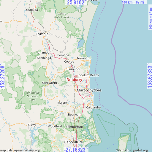
Ninderry GPS coordinates[2]
26° 32' 27.384" South, 152° 58' 30.72" East
| Map corner | latitude | longitude |
|---|---|---|
| Upper-left | -25.9102°, | 152.27208° |
| Center: | -26.54094°, | 152.9752° |
| Lower-right: | -27.16823°, | 153.67833° |
| Map W x H: | 139.9×139.9 km | = 86.9×86.9mi |
| max Lat: | -10.58257° ⇑12.6% North |
| Ninderry: | -26.54094° |
| min Lat: | ⇓87.4% South -43.31423° |
| min Long | Ninderry | max Long |
| 113.53327° | 152.9752° | 153.61246° |
| W 90.3%⇐ | ⇒9.7% E |
Elevation
Elevation of Ninderry is 45 m = 148 ft, and this is 77 m = 253 ft below average elevation for this country.
| Max E: |
1715 m = 5627 ft | 50.4% |
| Avg. | 122 m = 400 ft | |
| Ninderry | 45 m = 148 ft | |
Min E: |
-2 m = -7 ft | 49.6% |
See also: Australia elevation on elevation.city.
Geographical zone
Ninderry is located in South temperate zone (between Tropic of Capricorn and the Antarctic Circle). Distance of this Southern Tropic circle is 345.2 km =214.5 mi to North.| Distance of | km | miles | from Ninderry |
|---|---|---|---|
| Equator | 2951.1 | 1833.7 | to North |
| Tropic Capricorn | 345.2 | 214.5 | to North |
| Antarctic Circle | 4450.1 | 2765.2 | to South |
| South Pole | 7056 | 4384.4 | to South |


Nearby cities:
15 places around Ninderry: (largest is in red/bold)
• Bli Bli
10.5 km =6.5 mi,  144°
144°
• Burnside
10.8 km =6.7 mi,  198°
198°
• Coolum Beach
11.3 km =7 mi,  82°
82°
• Doonan
11.4 km =7.1 mi,  8°
8°
• Eerwah Vale
9.4 km =5.8 mi,  317°
317°
• Eumundi
7.5 km =4.7 mi,  341°
341°
• Kureelpa
11.1 km =6.9 mi,  228°
228°
• Maroochy River
6 km =3.7 mi,  133°
133°
• Nambour
9.6 km =6 mi,  189°
189°
• North Arm
2.7 km =1.7 mi,  312°
312°
• Peregian Springs
11.6 km =7.2 mi,  59°
59°
• Rosemount
10.2 km =6.3 mi,  166°
166°
• Verrierdale
6.9 km =4.3 mi,  19°
19°
• Yandina
3 km =1.9 mi,  219°
219°
• Yandina Creek
6.3 km =3.9 mi,  87°
87°
Sources, notices
• [Note1] Compared only with cities in Australia existing in our database
• [Src1] Map data: © OpenStreetMap contributors (CC-BY-SA)
• [Src2] Other city data from geonames.org with taken over terms of usage.
• [Src3] Geographical zone / Annual Mean Temperature by Robert A. Rohde @ Wikipedia
