Don geodata
Don (Tasmania) is a populated place; located in Australia in Australia/Hobart (GMT+11) time zone. With population of 603 people, there are 4557 cities with bigger population in this country. Compared to other cities in Australia, 96.9% of cities are located further ↑North; 56% of cities are located further →East and 67.2% of cities have higher elevation than Don. Note1


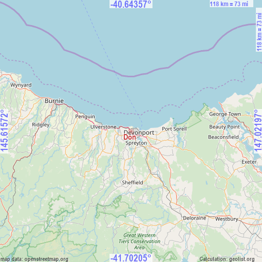
Don GPS coordinates[2]
41° 10' 29.82" South, 146° 19' 7.824" East
| Map corner | latitude | longitude |
|---|---|---|
| Upper-left | -40.64357°, | 145.61572° |
| Center: | -41.17495°, | 146.31884° |
| Lower-right: | -41.70205°, | 147.02197° |
| Map W x H: | 117.7×117.7 km | = 73.1×73.1mi |
| max Lat: | -10.58257° ⇑96.9% North |
| Don: | -41.17495° |
| min Lat: | ⇓3.1% South -43.31423° |
| min Long | Don | max Long |
| 113.53327° | 146.31884° | 153.61246° |
| W 44%⇐ | ⇒56% E |
Elevation
Elevation of Don is 25 m = 82 ft, and this is 97 m = 318 ft below average elevation for this country.
| Max E: |
1715 m = 5627 ft | 67.2% |
| Avg. | 122 m = 400 ft | |
| Don | 25 m = 82 ft | |
Min E: |
-2 m = -7 ft | 32.8% |
See also: Australia elevation on elevation.city.
Geographical zone
Don is located in South temperate zone (between Tropic of Capricorn and the Antarctic Circle). Distance of this Southern Tropic circle is 1972.3 km =1225.5 mi to North.| Distance of | km | miles | from Don |
|---|---|---|---|
| Equator | 4578.2 | 2844.8 | to North |
| Tropic Capricorn | 1972.3 | 1225.5 | to North |
| Antarctic Circle | 2822.9 | 1754.1 | to South |
| South Pole | 5428.8 | 3373.3 | to South |


Nearby cities:
15 places around Don: (largest is in red/bold)
• Ambleside
5.5 km =3.4 mi,  125°
125°
• Devonport
2.7 km =1.7 mi,  94°
94°
• East Devonport
5.9 km =3.7 mi,  104°
104°
• Forth
8.7 km =5.4 mi,  242°
242°
• Gawler
13.7 km =8.5 mi,  261°
261°
• Latrobe
11.9 km =7.4 mi, 131°
• Miandetta
3.7 km =2.3 mi, 128°
• Port Sorell
19.6 km =12.2 mi, 87°
• Railton
20.9 km =13 mi,  155°
155°
• Shearwater
17.9 km =11.1 mi,  83°
83°
• Spreyton
7.2 km =4.5 mi, 158°
• Stony Rise
2.5 km =1.6 mi, 157°
• Turners Beach
7.4 km =4.6 mi,  282°
282°
• Ulverstone
11.5 km =7.1 mi, 278°
• West Ulverstone
16.4 km =10.2 mi, 280°
Sources, notices
• [Note1] Compared only with cities in Australia existing in our database
• [Src1] Map data: © OpenStreetMap contributors (CC-BY-SA)
• [Src2] Other city data from geonames.org with taken over terms of usage.
• [Src3] Geographical zone / Annual Mean Temperature by Robert A. Rohde @ Wikipedia
