Forth geodata
Forth (Tasmania) is a populated place; located in Australia in Australia/Hobart (GMT+11) time zone. With population of 680 people, there are 4361 cities with bigger population in this country. Compared to other cities in Australia, 97% of cities are located further ↑North; 56.3% of cities are located further →East and 77.1% of cities have lower elevation than Forth. Note1


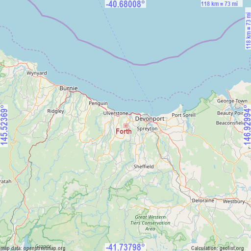
Forth GPS coordinates[2]
41° 12' 40.212" South, 146° 13' 36.516" East
| Map corner | latitude | longitude |
|---|---|---|
| Upper-left | -40.68008°, | 145.52369° |
| Center: | -41.21117°, | 146.22681° |
| Lower-right: | -41.73798°, | 146.92994° |
| Map W x H: | 117.6×117.6 km | = 73.1×73.1mi |
| max Lat: | -10.58257° ⇑97% North |
| Forth: | -41.21117° |
| min Lat: | ⇓3% South -43.31423° |
| min Long | Forth | max Long |
| 113.53327° | 146.22681° | 153.61246° |
| W 43.7%⇐ | ⇒56.3% E |
Elevation
Elevation of Forth is 149 m = 489 ft, and this is 27 m = 89 ft above average elevation for this country.
| Max E: |
1715 m = 5627 ft | 22.9% |
| Forth | 149 m 489 ft | |
| Avg. | 122 m = 400 ft | |
Min E: |
-2 m = -7 ft | 77.1% |
See also: Australia elevation on elevation.city.
Geographical zone
Forth is located in South temperate zone (between Tropic of Capricorn and the Antarctic Circle). Distance of this Southern Tropic circle is 1976.3 km =1228 mi to North.| Distance of | km | miles | from Forth |
|---|---|---|---|
| Equator | 4582.3 | 2847.3 | to North |
| Tropic Capricorn | 1976.3 | 1228 | to North |
| Antarctic Circle | 2818.9 | 1751.6 | to South |
| South Pole | 5424.8 | 3370.8 | to South |


Nearby cities:
15 places around Forth: (largest is in red/bold)
• Ambleside
12.2 km =7.6 mi,  85°
85°
• Devonport
11.1 km =6.9 mi,  69°
69°
• Don
8.7 km =5.4 mi,  62°
62°
• East Devonport
13.6 km =8.5 mi,  79°
79°
• Gawler
6.2 km =3.9 mi,  288°
288°
• Latrobe
17 km =10.6 mi,  103°
103°
• Miandetta
10.7 km =6.6 mi, 80°
• Penguin
16.2 km =10.1 mi,  307°
307°
• Railton
22.2 km =13.8 mi,  132°
132°
• Spreyton
10.7 km =6.6 mi, 104°
• Stony Rise
8.8 km =5.5 mi, 78°
• Sulphur Creek
21.4 km =13.3 mi, 307°
• Turners Beach
5.6 km =3.5 mi,  4°
4°
• Ulverstone
6.8 km =4.2 mi,  326°
326°
• West Ulverstone
11 km =6.8 mi, 310°
Sources, notices
• [Note1] Compared only with cities in Australia existing in our database
• [Src1] Map data: © OpenStreetMap contributors (CC-BY-SA)
• [Src2] Other city data from geonames.org with taken over terms of usage.
• [Src3] Geographical zone / Annual Mean Temperature by Robert A. Rohde @ Wikipedia
