East Devonport geodata
East Devonport (Tasmania) is a populated place; located in Australia in Australia/Hobart (GMT+11) time zone. With population of 4,016 people, there are 1786 cities with bigger population in this country. Compared to other cities in Australia, 96.9% of cities are located further ↑North; 55.7% of cities are located further →East and 51.1% of cities have lower elevation than East Devonport. Note1


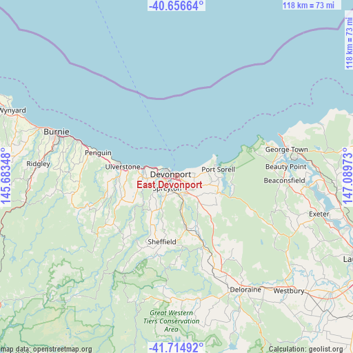
East Devonport GPS coordinates[2]
41° 11' 16.512" South, 146° 23' 11.76" East
| Map corner | latitude | longitude |
|---|---|---|
| Upper-left | -40.65664°, | 145.68348° |
| Center: | -41.18792°, | 146.3866° |
| Lower-right: | -41.71492°, | 147.08973° |
| Map W x H: | 117.7×117.7 km | = 73.1×73.1mi |
| max Lat: | -10.58257° ⇑96.9% North |
| East Devonport: | -41.18792° |
| min Lat: | ⇓3.1% South -43.31423° |
| min Long | East Devonport | max Long |
| 113.53327° | 146.3866° | 153.61246° |
| W 44.3%⇐ | ⇒55.7% E |
Elevation
Elevation of East Devonport is 47 m = 154 ft, and this is 75 m = 246 ft below average elevation for this country.
| Max E: |
1715 m = 5627 ft | 48.9% |
| Avg. | 122 m = 400 ft | |
| East Devonport | 47 m = 154 ft | |
Min E: |
-2 m = -7 ft | 51.1% |
See also: Australia elevation on elevation.city.
Geographical zone
East Devonport is located in South temperate zone (between Tropic of Capricorn and the Antarctic Circle). Distance of this Southern Tropic circle is 1973.7 km =1226.4 mi to North.| Distance of | km | miles | from East Devonport |
|---|---|---|---|
| Equator | 4579.7 | 2845.7 | to North |
| Tropic Capricorn | 1973.7 | 1226.4 | to North |
| Antarctic Circle | 2821.5 | 1753.2 | to South |
| South Pole | 5427.4 | 3372.4 | to South |


Nearby cities:
15 places around East Devonport: (largest is in red/bold)
• Ambleside
2.1 km =1.3 mi,  215°
215°
• Devonport
3.2 km =2 mi,  292°
292°
• Don
5.9 km =3.7 mi,  284°
284°
• Forth
13.6 km =8.5 mi,  259°
259°
• Gawler
19.2 km =11.9 mi,  268°
268°
• Latrobe
7.2 km =4.5 mi,  153°
153°
• Miandetta
2.9 km =1.8 mi,  253°
253°
• Port Sorell
14.1 km =8.8 mi,  80°
80°
• Railton
17.8 km =11.1 mi,  169°
169°
• Shearwater
12.6 km =7.8 mi,  74°
74°
• Spreyton
6 km =3.7 mi,  209°
209°
• Stony Rise
4.8 km =3 mi, 259°
• Turners Beach
13.3 km =8.3 mi, 283°
• Ulverstone
17.4 km =10.8 mi, 280°
• West Ulverstone
22.2 km =13.8 mi, 281°
Sources, notices
• [Note1] Compared only with cities in Australia existing in our database
• [Src1] Map data: © OpenStreetMap contributors (CC-BY-SA)
• [Src2] Other city data from geonames.org with taken over terms of usage.
• [Src3] Geographical zone / Annual Mean Temperature by Robert A. Rohde @ Wikipedia
