Casuarina geodata
Casuarina (New South Wales) is a section of populated place; located in Australia in Australia/Sydney (GMT+11) time zone. With population of 2,700 people, there are 2435 cities with bigger population in this country. Compared to other cities in Australia, 74.9% of cities are located further ↓South; 99.9% of cities are located further ←West and 86.8% of cities have higher elevation than Casuarina. Note1


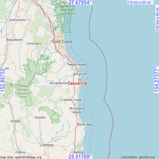
Casuarina GPS coordinates[2]
28° 18' 1.512" South, 153° 34' 14.304" East
| Map corner | latitude | longitude |
|---|---|---|
| Upper-left | -27.67954°, | 152.86752° |
| Center: | -28.30042°, | 153.57064° |
| Lower-right: | -28.91769°, | 154.27377° |
| Map W x H: | 137.7×137.7 km | = 85.6×85.6mi |
| max Lat: | -10.58257° ⇑25.1% North |
| Casuarina: | -28.30042° |
| min Lat: | ⇓74.9% South -43.31423° |
| min Long | Casuarina | max Long |
| 113.53327° | 153.57064° | 153.61246° |
| W 99.9%⇐ | ⇒0.099999999999994% E |
Elevation
Elevation of Casuarina is 11 m = 36 ft, and this is 111 m = 364 ft below average elevation for this country.
| Max E: |
1715 m = 5627 ft | 86.8% |
| Avg. | 122 m = 400 ft | |
| Casuarina | 11 m = 36 ft | |
Min E: |
-2 m = -7 ft | 13.2% |
See also: Australia elevation on elevation.city.
Geographical zone
Casuarina is located in South temperate zone (between Tropic of Capricorn and the Antarctic Circle). Distance of this Southern Tropic circle is 540.8 km =336 mi to North.| Distance of | km | miles | from Casuarina |
|---|---|---|---|
| Equator | 3146.7 | 1955.3 | to North |
| Tropic Capricorn | 540.8 | 336 | to North |
| Antarctic Circle | 4254.5 | 2643.6 | to South |
| South Pole | 6860.4 | 4262.9 | to South |


Nearby cities:
15 places around Casuarina: (largest is in red/bold)
• Banora Point
10.3 km =6.4 mi,  340°
340°
• Bilambil Heights
12.6 km =7.8 mi,  317°
317°
• Bogangar
3.2 km =2 mi,  183°
183°
• Chinderah
6.1 km =3.8 mi,  327°
327°
• Cudgen
4.3 km =2.7 mi, 331°
• Fingal Head
11 km =6.8 mi,  357°
357°
• Hastings Point
7.1 km =4.4 mi, 176°
• Kingscliff
4.6 km =2.9 mi,  9°
9°
• Nunderi
11.1 km =6.9 mi,  257°
257°
• Pottsville
9.7 km =6 mi,  186°
186°
• Pottsville Beach
9.8 km =6.1 mi, 182°
• Terranora
9.7 km =6 mi, 315°
• Tweed Heads
14 km =8.7 mi,  349°
349°
• Tweed Heads South
12.1 km =7.5 mi, 345°
• Tweed Heads West
13.4 km =8.3 mi, 339°
Sources, notices
• [Note1] Compared only with cities in Australia existing in our database
• [Src1] Map data: © OpenStreetMap contributors (CC-BY-SA)
• [Src2] Other city data from geonames.org with taken over terms of usage.
• [Src3] Geographical zone / Annual Mean Temperature by Robert A. Rohde @ Wikipedia
