Nunderi geodata
Nunderi (New South Wales) is a section of populated place; located in Australia in Australia/Sydney (GMT+11) time zone. With population of 657 people, there are 4419 cities with bigger population in this country. Compared to other cities in Australia, 74.9% of cities are located further ↓South; 99.2% of cities are located further ←West and 59.3% of cities have lower elevation than Nunderi. Note1


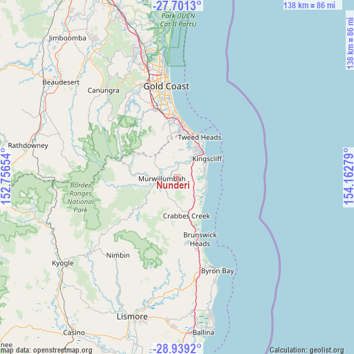
Nunderi GPS coordinates[2]
28° 19' 19.38" South, 153° 27' 34.776" East
| Map corner | latitude | longitude |
|---|---|---|
| Upper-left | -27.7013°, | 152.75654° |
| Center: | -28.32205°, | 153.45966° |
| Lower-right: | -28.9392°, | 154.16279° |
| Map W x H: | 137.6×137.6 km | = 85.5×85.5mi |
| max Lat: | -10.58257° ⇑25.1% North |
| Nunderi: | -28.32205° |
| min Lat: | ⇓74.9% South -43.31423° |
| min Long | Nunderi | max Long |
| 113.53327° | 153.45966° | 153.61246° |
| W 99.2%⇐ | ⇒0.8% E |
Elevation
Elevation of Nunderi is 62 m = 203 ft, and this is 60 m = 197 ft below average elevation for this country.
| Max E: |
1715 m = 5627 ft | 40.7% |
| Avg. | 122 m = 400 ft | |
| Nunderi | 62 m = 203 ft | |
Min E: |
-2 m = -7 ft | 59.3% |
See also: Australia elevation on elevation.city.
Geographical zone
Nunderi is located in South temperate zone (between Tropic of Capricorn and the Antarctic Circle). Distance of this Southern Tropic circle is 543.2 km =337.5 mi to North.| Distance of | km | miles | from Nunderi |
|---|---|---|---|
| Equator | 3149.1 | 1956.8 | to North |
| Tropic Capricorn | 543.2 | 337.5 | to North |
| Antarctic Circle | 4252.1 | 2642.1 | to South |
| South Pole | 6857.9 | 4261.3 | to South |


Nearby cities:
15 places around Nunderi: (largest is in red/bold)
• Bilambil Heights
12 km =7.5 mi,  11°
11°
• Bogangar
10.7 km =6.6 mi,  94°
94°
• Bray Park
8.5 km =5.3 mi,  255°
255°
• Burringbar
12.7 km =7.9 mi,  174°
174°
• Casuarina
11.1 km =6.9 mi,  77°
77°
• Chinderah
10.7 km =6.6 mi,  45°
45°
• Cudgen
10.8 km =6.7 mi,  55°
55°
• Hastings Point
12.2 km =7.6 mi,  112°
112°
• Kingscliff
13.5 km =8.4 mi, 59°
• Murwillumbah
6.5 km =4 mi, 264°
• Pottsville
12.1 km =7.5 mi,  126°
126°
• Pottsville Beach
12.7 km =7.9 mi, 125°
• South Murwillumbah
6.1 km =3.8 mi,  252°
252°
• Stokers Siding
10.6 km =6.6 mi,  204°
204°
• Terranora
10.1 km =6.3 mi,  23°
23°
Sources, notices
• [Note1] Compared only with cities in Australia existing in our database
• [Src1] Map data: © OpenStreetMap contributors (CC-BY-SA)
• [Src2] Other city data from geonames.org with taken over terms of usage.
• [Src3] Geographical zone / Annual Mean Temperature by Robert A. Rohde @ Wikipedia
