Bungendore geodata
Bungendore (New South Wales) is a populated place; located in Australia in Australia/Sydney (GMT+11) time zone. With population of 4,067 people, there are 1766 cities with bigger population in this country. Compared to other cities in Australia, 75% of cities are located further ↑North; 56% of cities are located further ←West and 98.3% of cities have lower elevation than Bungendore. Note1


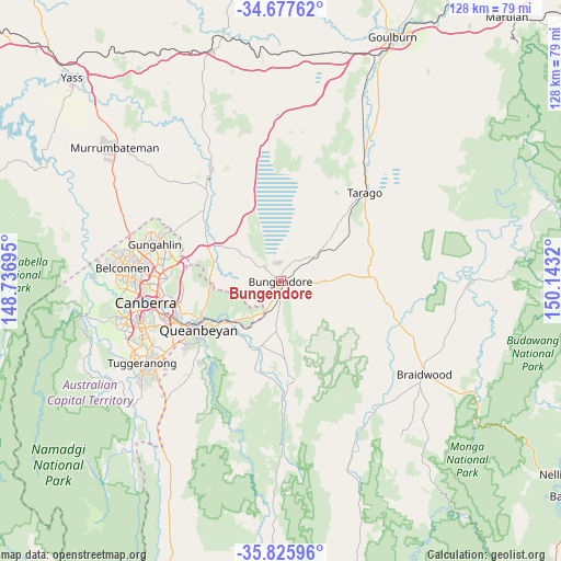
Bungendore GPS coordinates[2]
35° 15' 13.752" South, 149° 26' 24.252" East
| Map corner | latitude | longitude |
|---|---|---|
| Upper-left | -34.67762°, | 148.73695° |
| Center: | -35.25382°, | 149.44007° |
| Lower-right: | -35.82596°, | 150.1432° |
| Map W x H: | 127.7×127.7 km | = 79.3×79.3mi |
| max Lat: | -10.58257° ⇑75% North |
| Bungendore: | -35.25382° |
| min Lat: | ⇓25% South -43.31423° |
| min Long | Bungendore | max Long |
| 113.53327° | 149.44007° | 153.61246° |
| W 56%⇐ | ⇒44% E |
Elevation
Elevation of Bungendore is 694 m = 2277 ft, and this is 572 m = 1877 ft above average elevation for this country.
| Max E: |
1715 m = 5627 ft | 1.7% |
| Bungendore | 694 m 2277 ft | |
| Avg. | 122 m = 400 ft | |
Min E: |
-2 m = -7 ft | 98.3% |
See also: Australia elevation on elevation.city.
Geographical zone
Bungendore is located in South temperate zone (between Tropic of Capricorn and the Antarctic Circle). Distance of this Southern Tropic circle is 1313.9 km =816.4 mi to North.| Distance of | km | miles | from Bungendore |
|---|---|---|---|
| Equator | 3919.9 | 2435.7 | to North |
| Tropic Capricorn | 1313.9 | 816.4 | to North |
| Antarctic Circle | 3481.3 | 2163.2 | to South |
| South Pole | 6087.2 | 3782.4 | to South |


Nearby cities:
15 places around Bungendore: (largest is in red/bold)
• Bywong
14.1 km =8.8 mi,  314°
314°
• Campbell
26.3 km =16.3 mi,  261°
261°
• Carwoola
17.5 km =10.9 mi,  217°
217°
• Crestwood
22.8 km =14.2 mi,  242°
242°
• Greenleigh
21.1 km =13.1 mi,  233°
233°
• Hackett
25.1 km =15.6 mi,  271°
271°
• Harrison
26.5 km =16.5 mi,  283°
283°
• Jerrabomberra
26 km =16.2 mi, 236°
• Karabar
23.2 km =14.4 mi, 234°
• Queanbeyan
22 km =13.7 mi, 239°
• Queanbeyan East
20.4 km =12.7 mi, 239°
• Queanbeyan West
24.2 km =15 mi, 242°
• Sutton
19.8 km =12.3 mi,  299°
299°
• Wamboin
9.7 km =6 mi, 272°
• Watson
26.2 km =16.3 mi, 273°
Sources, notices
• [Note1] Compared only with cities in Australia existing in our database
• [Src1] Map data: © OpenStreetMap contributors (CC-BY-SA)
• [Src2] Other city data from geonames.org with taken over terms of usage.
• [Src3] Geographical zone / Annual Mean Temperature by Robert A. Rohde @ Wikipedia
